You are here: Home > Network List > HL - National Observatory of Athens Digital Broadband Network Stations List
> Station ITM ITHOMI, GREECE > Earthquake Result Viewer
ITM ITHOMI, GREECE - Earthquake Result Viewer
| Earthquake location: |
North Atlantic Ocean |
| Earthquake latitude/longitude: |
14.7/-58.9 |
| Earthquake time(UTC): |
2014/02/18 (049) 09:27:13 GMT |
| Earthquake Depth: |
17 km |
| Earthquake Magnitude: |
6.5 MWW, 6.3 MWB, 6.5 MWC, 6.6 MWC, 6.7 MI |
| Earthquake Catalog/Contributor: |
NEIC PDE/NEIC COMCAT |
|
| Network: |
HL National Observatory of Athens Digital Broadband Network |
| Station: |
ITM ITHOMI, GREECE |
| Lat/Lon: |
37.18 N/21.93 E |
| Elevation: |
400 m |
|
| Distance: |
74.1 deg |
| Az: |
55.08 deg |
| Baz: |
276.459 deg |
| Ray Param: |
0.052553605 |
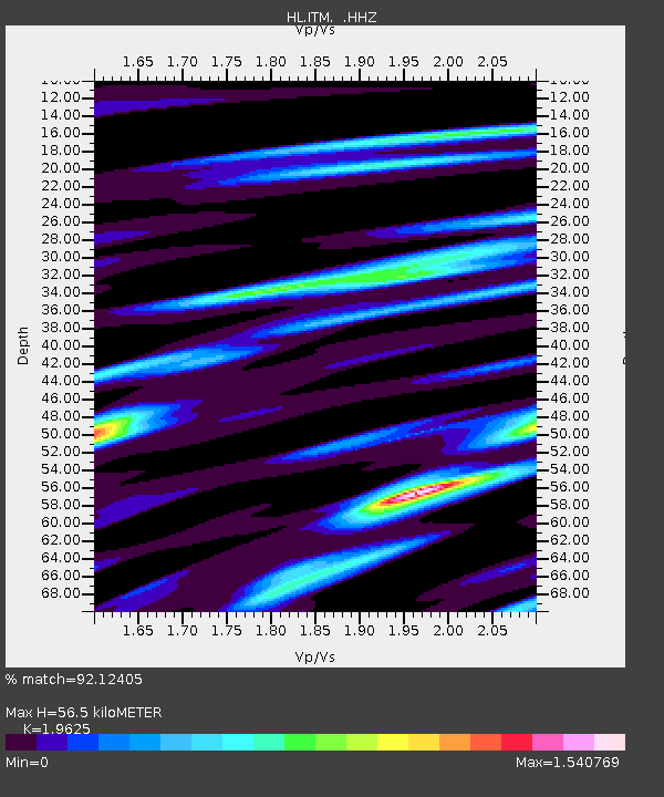
| Estimated Moho Depth: |
56.5 km |
| Estimated Crust Vp/Vs: |
1.96 |
| Assumed Crust Vp: |
5.627 km/s |
| Estimated Crust Vs: |
2.867 km/s |
| Estimated Crust Poisson's Ratio: |
0.32 |
|
| Radial Match: |
92.12405 % |
| Radial Bump: |
400 |
| Transverse Match: |
86.90724 % |
| Transverse Bump: |
400 |
| SOD ConfigId: |
626651 |
| Insert Time: |
2014-04-20 18:57:35.531 +0000 |
| GWidth: |
2.5 |
| Max Bumps: |
400 |
| Tol: |
0.001 |
|

Signal To Noise
| Channel | StoN | STA | LTA |
| HL:ITM: :HHZ:20140218T09:38:17.180017Z | 26.168703 | 2.467855E-6 | 9.430559E-8 |
| HL:ITM: :HHN:20140218T09:38:17.180017Z | 2.2522051 | 2.1778847E-7 | 9.6700106E-8 |
| HL:ITM: :HHE:20140218T09:38:17.180017Z | 13.183678 | 1.1609591E-6 | 8.806034E-8 |
| Arrivals |
| Ps | 9.9 SECOND |
| PpPs | 29 SECOND |
| PsPs/PpSs | 39 SECOND |


