You are here: Home > Network List > IU - Global Seismograph Network (GSN - IRIS/USGS) Stations List
> Station WVT Waverly, Tennessee, USA > Earthquake Result Viewer
WVT Waverly, Tennessee, USA - Earthquake Result Viewer

| Earthquake location: |
North Atlantic Ocean |
| Earthquake latitude/longitude: |
14.7/-58.9 |
| Earthquake time(UTC): |
2014/02/18 (049) 09:27:13 GMT |
| Earthquake Depth: |
17 km |
| Earthquake Magnitude: |
6.5 MWW, 6.3 MWB, 6.5 MWC, 6.6 MWC, 6.7 MI |
| Earthquake Catalog/Contributor: |
NEIC PDE/NEIC COMCAT |
|
| Network: |
IU Global Seismograph Network (GSN - IRIS/USGS) |
| Station: |
WVT Waverly, Tennessee, USA |
| Lat/Lon: |
36.13 N/87.83 W |
| Elevation: |
170 m |
|
| Distance: |
33.5 deg |
| Az: |
314.912 deg |
| Baz: |
122.145 deg |
| Ray Param: |
0.078148 |
| Estimated Moho Depth: |
54.75 km |
| Estimated Crust Vp/Vs: |
1.63 |
| Assumed Crust Vp: |
6.444 km/s |
| Estimated Crust Vs: |
3.947 km/s |
| Estimated Crust Poisson's Ratio: |
0.20 |
|
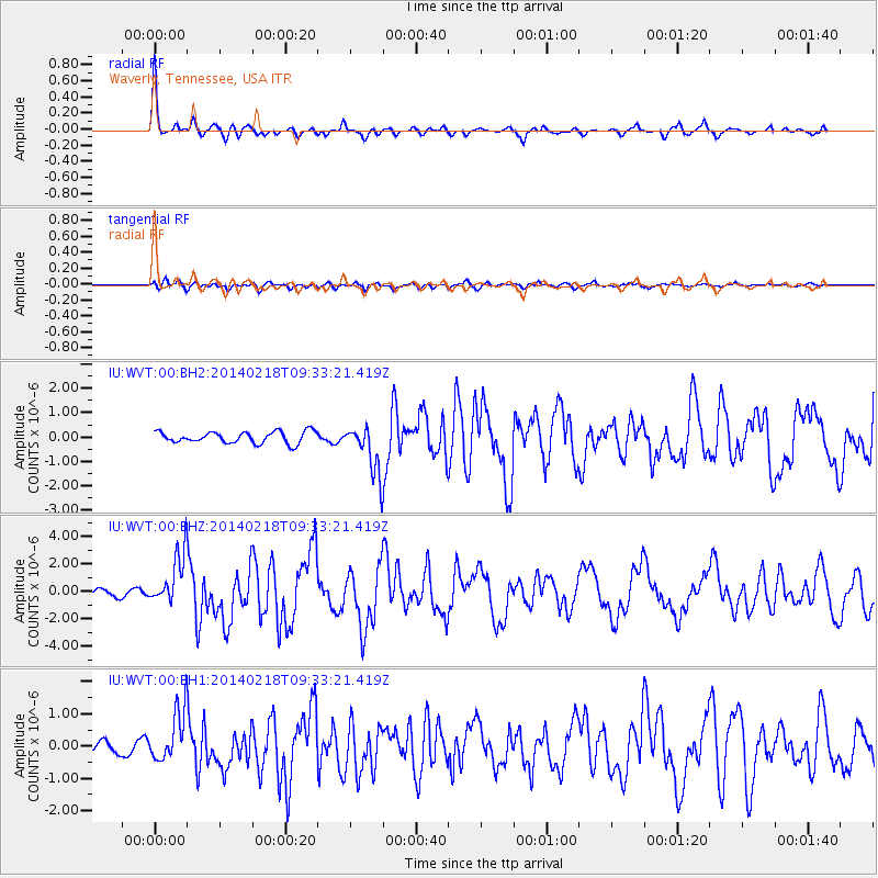
| Radial Match: |
88.952896 % |
| Radial Bump: |
308 |
| Transverse Match: |
80.33428 % |
| Transverse Bump: |
400 |
| SOD ConfigId: |
626651 |
| Insert Time: |
2014-04-20 18:59:59.823 +0000 |
| GWidth: |
2.5 |
| Max Bumps: |
400 |
| Tol: |
0.001 |
|
Signal To Noise
| Channel | StoN | STA | LTA |
| IU:WVT:00:BHZ:20140218T09:33:21.419Z | 5.24462 | 1.8595678E-6 | 3.5456674E-7 |
| IU:WVT:00:BH1:20140218T09:33:21.419Z | 2.7500532 | 7.740524E-7 | 2.8146817E-7 |
| IU:WVT:00:BH2:20140218T09:33:21.419Z | 4.298079 | 1.0154799E-6 | 2.3626367E-7 |
| Arrivals |
| Ps | 5.9 SECOND |
| PpPs | 21 SECOND |
| PsPs/PpSs | 26 SECOND |


