You are here: Home > Network List > AZ - ANZA Regional Network Stations List
> Station SMER AZ.SMER > Earthquake Result Viewer
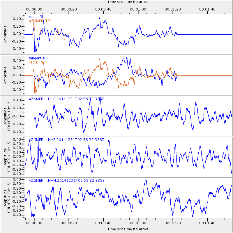
SMER AZ.SMER - Earthquake Result Viewer
*The percent match for this event was below the threshold and hence no stack was calculated.
| Earthquake location: |
South Of Fiji Islands |
| Earthquake latitude/longitude: |
-25.5/178.2 |
| Earthquake time(UTC): |
2014/12/31 (365) 02:47:31 GMT |
| Earthquake Depth: |
609 km |
| Earthquake Magnitude: |
5.5 MW, 5.1 mb |
| Earthquake Catalog/Contributor: |
ISC/ISC |
|
| Network: |
AZ ANZA Regional Network |
| Station: |
SMER AZ.SMER |
| Lat/Lon: |
33.46 N/117.17 W |
| Elevation: |
355 m |
|
| Distance: |
84.9 deg |
| Az: |
49.309 deg |
| Baz: |
235.054 deg |
| Ray Param: |
$rayparam |
*The percent match for this event was below the threshold and hence was not used in the summary stack. |
|
| Radial Match: |
42.420406 % |
| Radial Bump: |
400 |
| Transverse Match: |
35.23452 % |
| Transverse Bump: |
400 |
| SOD ConfigId: |
3390531 |
| Insert Time: |
2019-04-15 21:32:51.504 +0000 |
| GWidth: |
2.5 |
| Max Bumps: |
400 |
| Tol: |
0.001 |
|
Signal To Noise
| Channel | StoN | STA | LTA |
| AZ:SMER: :HHZ:20141231T02:58:32.338Z | 0.98411864 | 1.796353E-7 | 1.8253418E-7 |
| AZ:SMER: :HHN:20141231T02:58:32.338Z | 1.47289 | 2.9183133E-7 | 1.9813518E-7 |
| AZ:SMER: :HHE:20141231T02:58:32.338Z | 1.8786057 | 2.427512E-7 | 1.2921882E-7 |
| Arrivals |
| Ps | |
| PpPs | |
| PsPs/PpSs | |


