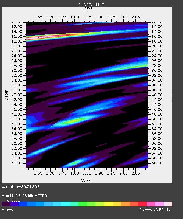
DRE Drenchia - Earthquake Result Viewer

Earthquake location: North Atlantic Ocean
Earthquake latitude/longitude: 14.7/-58.9
Earthquake time(UTC): 2014/02/18 (049) 09:27:13 GMT
Earthquake Depth: 17 km
Earthquake Magnitude: 6.5 MWW, 6.3 MWB, 6.5 MWC, 6.6 MWC, 6.7 MI
Earthquake Catalog/Contributor: NEIC PDE/NEIC COMCAT
Network: NI North-East Italy Broadband Network
Station: DRE Drenchia
Lat/Lon: 46.17 N/13.65 E
Elevation: 810 m
Distance: 67.5 deg
Az: 45.845 deg
Baz: 267.905 deg
Ray Param: 0.05688095
Estimated Moho Depth: 16.25 km
Estimated Crust Vp/Vs: 1.65
Assumed Crust Vp: 6.35 km/s
Estimated Crust Vs: 3.848 km/s
Estimated Crust Poisson's Ratio: 0.21
Radial Match: 85.51862 %
Radial Bump: 400
Transverse Match: 78.964676 %
Transverse Bump: 400
SOD ConfigId: 626651
Insert Time: 2014-04-20 19:04:25.018 +0000
GWidth: 2.5
Max Bumps: 400
Tol: 0.001

Signal To Noise

ChannelStoNSTALTA
NI:DRE: :HHZ:20140218T09:37:37.397974Z16.6490023.0032331E-61.8038517E-7
NI:DRE: :HHN:20140218T09:37:37.397974Z2.06735854.2161088E-72.0393699E-7
NI:DRE: :HHE:20140218T09:37:37.397974Z7.04282951.0688627E-61.5176609E-7
Arrivals
Ps1.7 SECOND
PpPs6.5 SECOND
PsPs/PpSs8.2 SECOND