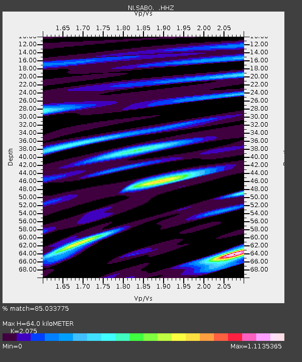
SABO Mt. Sabotino - Earthquake Result Viewer

Earthquake location: North Atlantic Ocean
Earthquake latitude/longitude: 14.7/-58.9
Earthquake time(UTC): 2014/02/18 (049) 09:27:13 GMT
Earthquake Depth: 17 km
Earthquake Magnitude: 6.5 MWW, 6.3 MWB, 6.5 MWC, 6.6 MWC, 6.7 MI
Earthquake Catalog/Contributor: NEIC PDE/NEIC COMCAT
Network: NI North-East Italy Broadband Network
Station: SABO Mt. Sabotino
Lat/Lon: 45.99 N/13.63 E
Elevation: 621 m
Distance: 67.5 deg
Az: 46.046 deg
Baz: 267.974 deg
Ray Param: 0.056890476
Estimated Moho Depth: 64.0 km
Estimated Crust Vp/Vs: 2.08
Assumed Crust Vp: 6.207 km/s
Estimated Crust Vs: 2.991 km/s
Estimated Crust Poisson's Ratio: 0.35
Radial Match: 85.033775 %
Radial Bump: 400
Transverse Match: 71.048256 %
Transverse Bump: 400
SOD ConfigId: 626651
Insert Time: 2014-04-20 19:04:35.785 +0000
GWidth: 2.5
Max Bumps: 400
Tol: 0.001

Signal To Noise

ChannelStoNSTALTA
NI:SABO: :HHZ:20140218T09:37:37.308008Z7.5619152.8780396E-63.8059667E-7
NI:SABO: :HHN:20140218T09:37:37.308008Z1.97995776.0205446E-73.040744E-7
NI:SABO: :HHE:20140218T09:37:37.308008Z4.42745451.1204826E-62.5307602E-7
Arrivals
Ps11 SECOND
PpPs31 SECOND
PsPs/PpSs42 SECOND