You are here: Home > Network List > TA - USArray Transportable Network (new EarthScope stations) Stations List
> Station R11A Troy Canyon, Currant, NV, USA > Earthquake Result Viewer
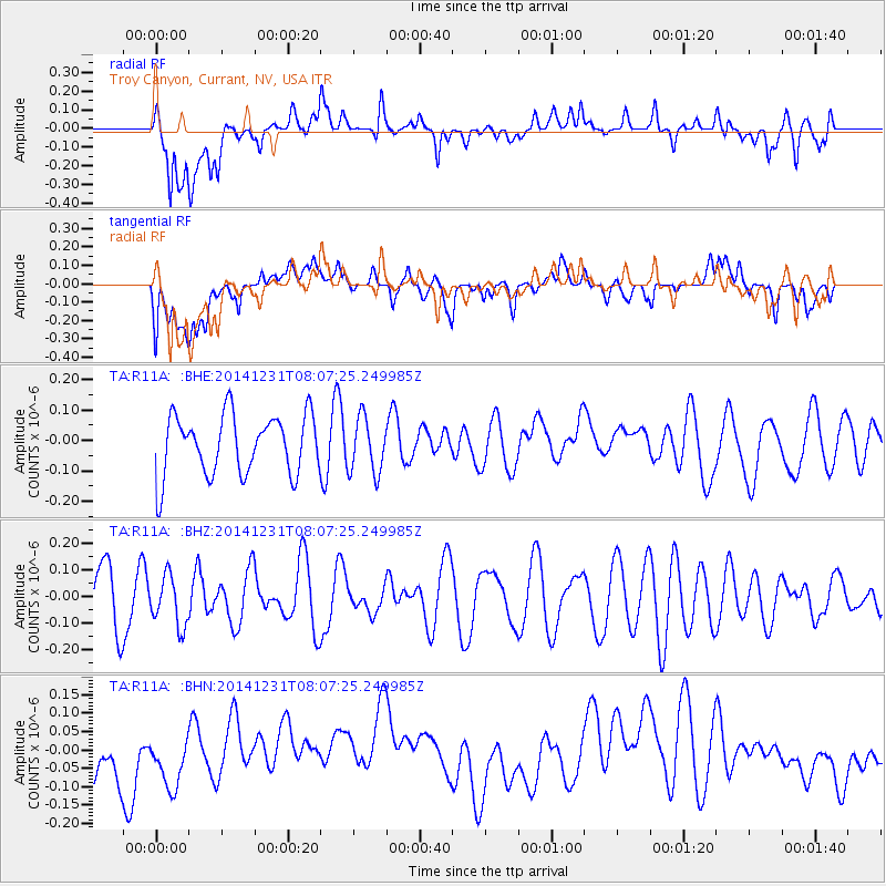
R11A Troy Canyon, Currant, NV, USA - Earthquake Result Viewer
*The percent match for this event was below the threshold and hence no stack was calculated.
| Earthquake location: |
Taiwan Region |
| Earthquake latitude/longitude: |
24.7/122.6 |
| Earthquake time(UTC): |
2014/12/31 (365) 07:54:36 GMT |
| Earthquake Depth: |
104 km |
| Earthquake Magnitude: |
5.0 MW, 5.5 ML, 5.2 mb |
| Earthquake Catalog/Contributor: |
ISC/ISC |
|
| Network: |
TA USArray Transportable Network (new EarthScope stations) |
| Station: |
R11A Troy Canyon, Currant, NV, USA |
| Lat/Lon: |
38.35 N/115.59 W |
| Elevation: |
1756 m |
|
| Distance: |
97.0 deg |
| Az: |
42.282 deg |
| Baz: |
308.88 deg |
| Ray Param: |
$rayparam |
*The percent match for this event was below the threshold and hence was not used in the summary stack. |
|
| Radial Match: |
45.543648 % |
| Radial Bump: |
400 |
| Transverse Match: |
30.793253 % |
| Transverse Bump: |
400 |
| SOD ConfigId: |
3390531 |
| Insert Time: |
2019-04-15 21:40:42.641 +0000 |
| GWidth: |
2.5 |
| Max Bumps: |
400 |
| Tol: |
0.001 |
|
Signal To Noise
| Channel | StoN | STA | LTA |
| TA:R11A: :BHZ:20141231T08:07:25.249985Z | 0.8823045 | 9.3762374E-8 | 1.0626986E-7 |
| TA:R11A: :BHN:20141231T08:07:25.249985Z | 0.7999765 | 1.2409522E-7 | 1.5512359E-7 |
| TA:R11A: :BHE:20141231T08:07:25.249985Z | 0.92589486 | 9.128823E-8 | 9.85946E-8 |
| Arrivals |
| Ps | |
| PpPs | |
| PsPs/PpSs | |


