You are here: Home > Network List > TA - USArray Transportable Network (new EarthScope stations) Stations List
> Station E44A Grand Marais Airport, Grand Marais, MI, USA > Earthquake Result Viewer
E44A Grand Marais Airport, Grand Marais, MI, USA - Earthquake Result Viewer
| Earthquake location: |
North Atlantic Ocean |
| Earthquake latitude/longitude: |
14.7/-58.9 |
| Earthquake time(UTC): |
2014/02/18 (049) 09:27:13 GMT |
| Earthquake Depth: |
17 km |
| Earthquake Magnitude: |
6.5 MWW, 6.3 MWB, 6.5 MWC, 6.6 MWC, 6.7 MI |
| Earthquake Catalog/Contributor: |
NEIC PDE/NEIC COMCAT |
|
| Network: |
TA USArray Transportable Network (new EarthScope stations) |
| Station: |
E44A Grand Marais Airport, Grand Marais, MI, USA |
| Lat/Lon: |
46.62 N/85.92 W |
| Elevation: |
282 m |
|
| Distance: |
39.1 deg |
| Az: |
330.229 deg |
| Baz: |
135.793 deg |
| Ray Param: |
0.07518989 |
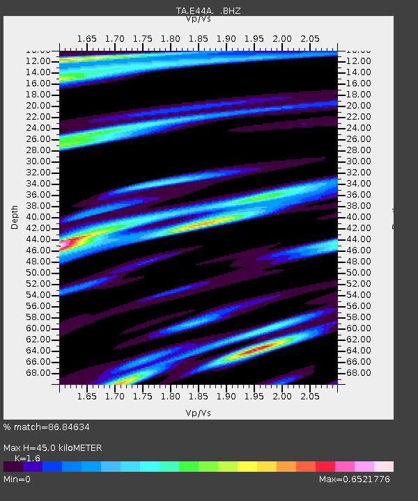
| Estimated Moho Depth: |
45.0 km |
| Estimated Crust Vp/Vs: |
1.60 |
| Assumed Crust Vp: |
6.467 km/s |
| Estimated Crust Vs: |
4.042 km/s |
| Estimated Crust Poisson's Ratio: |
0.18 |
|
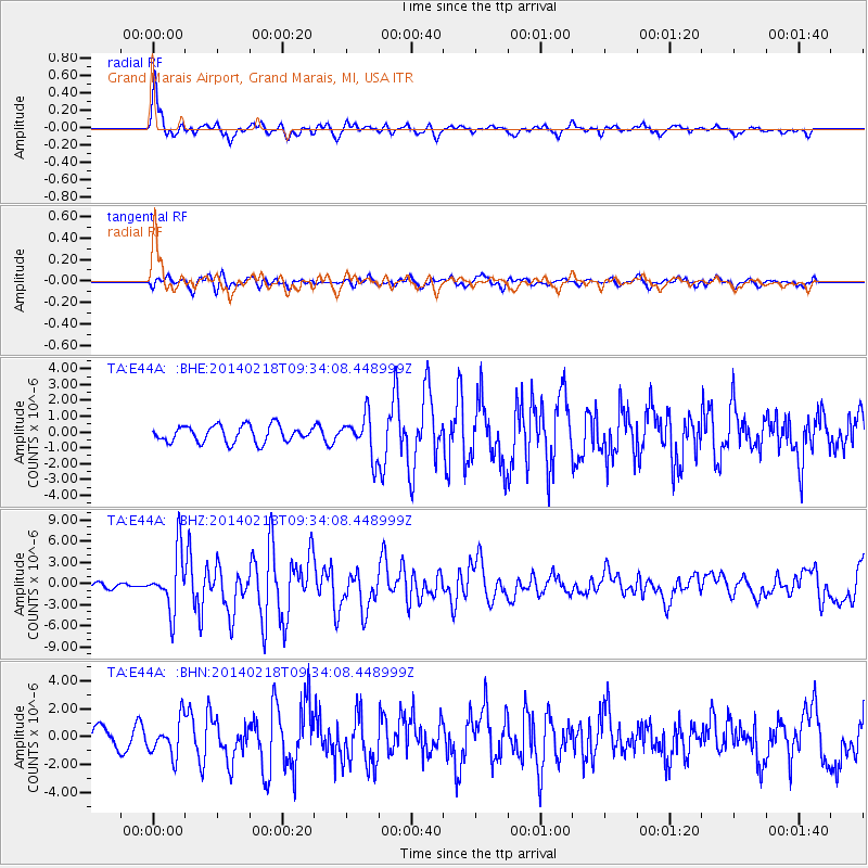
| Radial Match: |
86.84634 % |
| Radial Bump: |
376 |
| Transverse Match: |
70.63081 % |
| Transverse Bump: |
400 |
| SOD ConfigId: |
626651 |
| Insert Time: |
2014-04-20 19:10:29.920 +0000 |
| GWidth: |
2.5 |
| Max Bumps: |
400 |
| Tol: |
0.001 |
|
Signal To Noise
| Channel | StoN | STA | LTA |
| TA:E44A: :BHZ:20140218T09:34:08.448999Z | 14.166838 | 4.090691E-6 | 2.8875118E-7 |
| TA:E44A: :BHN:20140218T09:34:08.448999Z | 1.5885457 | 1.2841585E-6 | 8.083863E-7 |
| TA:E44A: :BHE:20140218T09:34:08.448999Z | 2.4465234 | 1.2821038E-6 | 5.240513E-7 |
| Arrivals |
| Ps | 4.5 SECOND |
| PpPs | 17 SECOND |
| PsPs/PpSs | 21 SECOND |


