You are here: Home > Network List > TA - USArray Transportable Network (new EarthScope stations) Stations List
> Station E59A St. Maurice, QC, CAN > Earthquake Result Viewer
E59A St. Maurice, QC, CAN - Earthquake Result Viewer
| Earthquake location: |
North Atlantic Ocean |
| Earthquake latitude/longitude: |
14.7/-58.9 |
| Earthquake time(UTC): |
2014/02/18 (049) 09:27:13 GMT |
| Earthquake Depth: |
17 km |
| Earthquake Magnitude: |
6.5 MWW, 6.3 MWB, 6.5 MWC, 6.6 MWC, 6.7 MI |
| Earthquake Catalog/Contributor: |
NEIC PDE/NEIC COMCAT |
|
| Network: |
TA USArray Transportable Network (new EarthScope stations) |
| Station: |
E59A St. Maurice, QC, CAN |
| Lat/Lon: |
46.48 N/72.51 W |
| Elevation: |
62 m |
|
| Distance: |
33.7 deg |
| Az: |
343.001 deg |
| Baz: |
155.827 deg |
| Ray Param: |
0.0780664 |
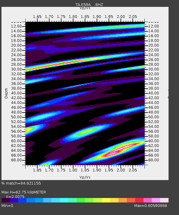
| Estimated Moho Depth: |
62.75 km |
| Estimated Crust Vp/Vs: |
2.01 |
| Assumed Crust Vp: |
6.61 km/s |
| Estimated Crust Vs: |
3.293 km/s |
| Estimated Crust Poisson's Ratio: |
0.33 |
|
| Radial Match: |
84.621155 % |
| Radial Bump: |
388 |
| Transverse Match: |
68.08388 % |
| Transverse Bump: |
400 |
| SOD ConfigId: |
626651 |
| Insert Time: |
2014-04-20 19:10:59.605 +0000 |
| GWidth: |
2.5 |
| Max Bumps: |
400 |
| Tol: |
0.001 |
|
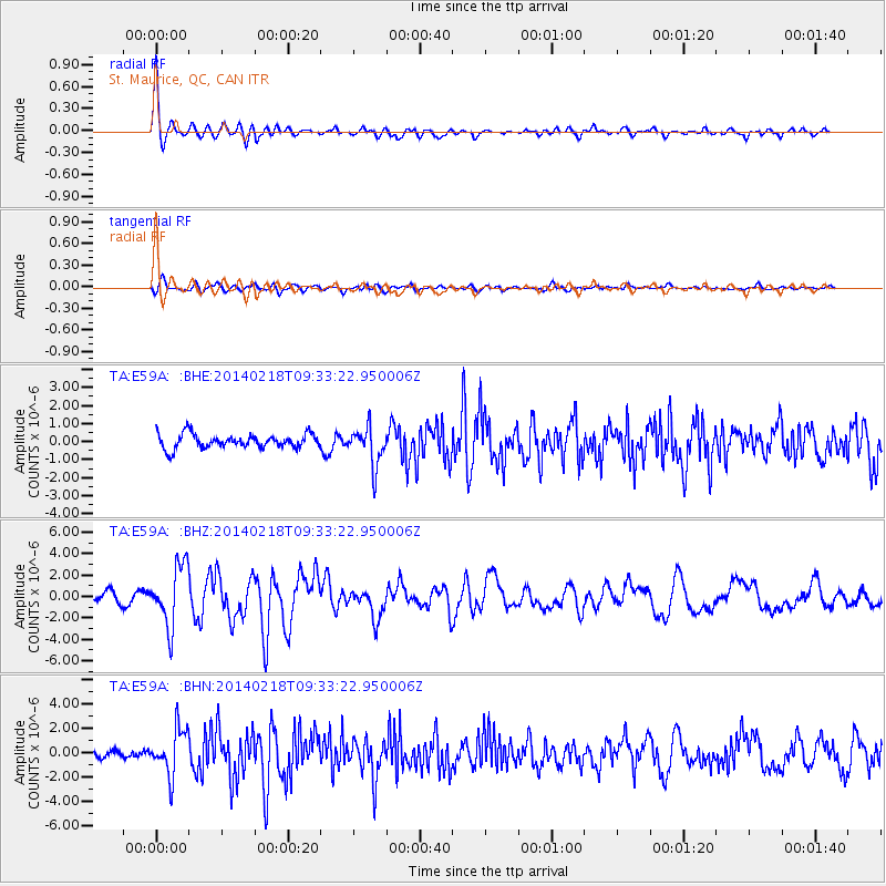
Signal To Noise
| Channel | StoN | STA | LTA |
| TA:E59A: :BHZ:20140218T09:33:22.950006Z | 4.8880987 | 2.8422055E-6 | 5.814542E-7 |
| TA:E59A: :BHN:20140218T09:33:22.950006Z | 5.5915456 | 1.8907972E-6 | 3.3815286E-7 |
| TA:E59A: :BHE:20140218T09:33:22.950006Z | 2.7295878 | 1.0638928E-6 | 3.8976316E-7 |
| Arrivals |
| Ps | 10 SECOND |
| PpPs | 27 SECOND |
| PsPs/PpSs | 37 SECOND |


