You are here: Home > Network List > TA - USArray Transportable Network (new EarthScope stations) Stations List
> Station E63A Oxbow, ME, USA > Earthquake Result Viewer
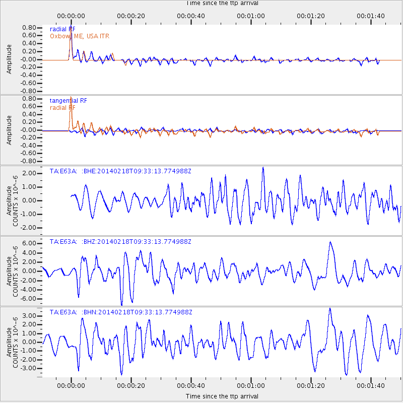
E63A Oxbow, ME, USA - Earthquake Result Viewer
*The percent match for this event was below the threshold and hence no stack was calculated.
| Earthquake location: |
North Atlantic Ocean |
| Earthquake latitude/longitude: |
14.7/-58.9 |
| Earthquake time(UTC): |
2014/02/18 (049) 09:27:13 GMT |
| Earthquake Depth: |
17 km |
| Earthquake Magnitude: |
6.5 MWW, 6.3 MWB, 6.5 MWC, 6.6 MWC, 6.7 MI |
| Earthquake Catalog/Contributor: |
NEIC PDE/NEIC COMCAT |
|
| Network: |
TA USArray Transportable Network (new EarthScope stations) |
| Station: |
E63A Oxbow, ME, USA |
| Lat/Lon: |
46.42 N/68.42 W |
| Elevation: |
238 m |
|
| Distance: |
32.7 deg |
| Az: |
347.795 deg |
| Baz: |
162.795 deg |
| Ray Param: |
$rayparam |
*The percent match for this event was below the threshold and hence was not used in the summary stack. |
|
| Radial Match: |
75.42826 % |
| Radial Bump: |
367 |
| Transverse Match: |
64.43756 % |
| Transverse Bump: |
400 |
| SOD ConfigId: |
626651 |
| Insert Time: |
2014-04-20 19:11:08.034 +0000 |
| GWidth: |
2.5 |
| Max Bumps: |
400 |
| Tol: |
0.001 |
|
Signal To Noise
| Channel | StoN | STA | LTA |
| TA:E63A: :BHZ:20140218T09:33:13.774988Z | 3.6805215 | 2.339462E-6 | 6.3563334E-7 |
| TA:E63A: :BHN:20140218T09:33:13.774988Z | 2.4240968 | 1.5816673E-6 | 6.5247696E-7 |
| TA:E63A: :BHE:20140218T09:33:13.774988Z | 1.1605302 | 6.142766E-7 | 5.293069E-7 |
| Arrivals |
| Ps | |
| PpPs | |
| PsPs/PpSs | |


