You are here: Home > Network List > TA - USArray Transportable Network (new EarthScope stations) Stations List
> Station F52A Sundridge, ON, CAN > Earthquake Result Viewer
F52A Sundridge, ON, CAN - Earthquake Result Viewer
| Earthquake location: |
North Atlantic Ocean |
| Earthquake latitude/longitude: |
14.7/-58.9 |
| Earthquake time(UTC): |
2014/02/18 (049) 09:27:13 GMT |
| Earthquake Depth: |
17 km |
| Earthquake Magnitude: |
6.5 MWW, 6.3 MWB, 6.5 MWC, 6.6 MWC, 6.7 MI |
| Earthquake Catalog/Contributor: |
NEIC PDE/NEIC COMCAT |
|
| Network: |
TA USArray Transportable Network (new EarthScope stations) |
| Station: |
F52A Sundridge, ON, CAN |
| Lat/Lon: |
45.80 N/79.32 W |
| Elevation: |
351 m |
|
| Distance: |
35.5 deg |
| Az: |
335.164 deg |
| Baz: |
144.474 deg |
| Ray Param: |
0.077184156 |
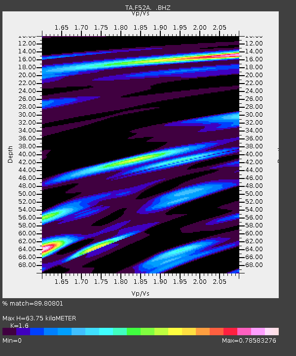
| Estimated Moho Depth: |
63.75 km |
| Estimated Crust Vp/Vs: |
1.60 |
| Assumed Crust Vp: |
6.577 km/s |
| Estimated Crust Vs: |
4.111 km/s |
| Estimated Crust Poisson's Ratio: |
0.18 |
|
| Radial Match: |
89.80801 % |
| Radial Bump: |
284 |
| Transverse Match: |
66.66059 % |
| Transverse Bump: |
400 |
| SOD ConfigId: |
626651 |
| Insert Time: |
2014-04-20 19:11:36.459 +0000 |
| GWidth: |
2.5 |
| Max Bumps: |
400 |
| Tol: |
0.001 |
|
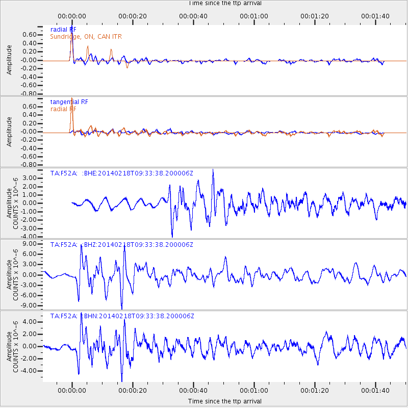
Signal To Noise
| Channel | StoN | STA | LTA |
| TA:F52A: :BHZ:20140218T09:33:38.200006Z | 6.724767 | 3.9123074E-6 | 5.817759E-7 |
| TA:F52A: :BHN:20140218T09:33:38.200006Z | 5.4314656 | 2.317756E-6 | 4.2672758E-7 |
| TA:F52A: :BHE:20140218T09:33:38.200006Z | 3.432424 | 1.4499468E-6 | 4.224265E-7 |
| Arrivals |
| Ps | 6.4 SECOND |
| PpPs | 23 SECOND |
| PsPs/PpSs | 29 SECOND |


