You are here: Home > Network List > TA - USArray Transportable Network (new EarthScope stations) Stations List
> Station F57A Harrington, QC, CAN > Earthquake Result Viewer
F57A Harrington, QC, CAN - Earthquake Result Viewer
| Earthquake location: |
North Atlantic Ocean |
| Earthquake latitude/longitude: |
14.7/-58.9 |
| Earthquake time(UTC): |
2014/02/18 (049) 09:27:13 GMT |
| Earthquake Depth: |
17 km |
| Earthquake Magnitude: |
6.5 MWW, 6.3 MWB, 6.5 MWC, 6.6 MWC, 6.7 MI |
| Earthquake Catalog/Contributor: |
NEIC PDE/NEIC COMCAT |
|
| Network: |
TA USArray Transportable Network (new EarthScope stations) |
| Station: |
F57A Harrington, QC, CAN |
| Lat/Lon: |
45.81 N/74.69 W |
| Elevation: |
178 m |
|
| Distance: |
33.8 deg |
| Az: |
340.02 deg |
| Baz: |
151.78 deg |
| Ray Param: |
0.0780341 |
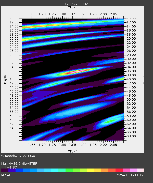
| Estimated Moho Depth: |
36.0 km |
| Estimated Crust Vp/Vs: |
1.87 |
| Assumed Crust Vp: |
6.419 km/s |
| Estimated Crust Vs: |
3.433 km/s |
| Estimated Crust Poisson's Ratio: |
0.30 |
|
| Radial Match: |
87.273964 % |
| Radial Bump: |
359 |
| Transverse Match: |
52.442608 % |
| Transverse Bump: |
400 |
| SOD ConfigId: |
626651 |
| Insert Time: |
2014-04-20 19:11:41.447 +0000 |
| GWidth: |
2.5 |
| Max Bumps: |
400 |
| Tol: |
0.001 |
|

Signal To Noise
| Channel | StoN | STA | LTA |
| TA:F57A: :BHZ:20140218T09:33:23.573999Z | 4.779199 | 2.082366E-6 | 4.3571444E-7 |
| TA:F57A: :BHN:20140218T09:33:23.573999Z | 3.3617063 | 1.4995181E-6 | 4.4605864E-7 |
| TA:F57A: :BHE:20140218T09:33:23.573999Z | 2.6723912 | 1.1996606E-6 | 4.4890905E-7 |
| Arrivals |
| Ps | 5.3 SECOND |
| PpPs | 15 SECOND |
| PsPs/PpSs | 20 SECOND |


