You are here: Home > Network List > TA - USArray Transportable Network (new EarthScope stations) Stations List
> Station F64A Sherman, ME, USA > Earthquake Result Viewer
F64A Sherman, ME, USA - Earthquake Result Viewer
| Earthquake location: |
North Atlantic Ocean |
| Earthquake latitude/longitude: |
14.7/-58.9 |
| Earthquake time(UTC): |
2014/02/18 (049) 09:27:13 GMT |
| Earthquake Depth: |
17 km |
| Earthquake Magnitude: |
6.5 MWW, 6.3 MWB, 6.5 MWC, 6.6 MWC, 6.7 MI |
| Earthquake Catalog/Contributor: |
NEIC PDE/NEIC COMCAT |
|
| Network: |
TA USArray Transportable Network (new EarthScope stations) |
| Station: |
F64A Sherman, ME, USA |
| Lat/Lon: |
45.86 N/68.35 W |
| Elevation: |
179 m |
|
| Distance: |
32.1 deg |
| Az: |
347.575 deg |
| Baz: |
162.661 deg |
| Ray Param: |
0.078777485 |
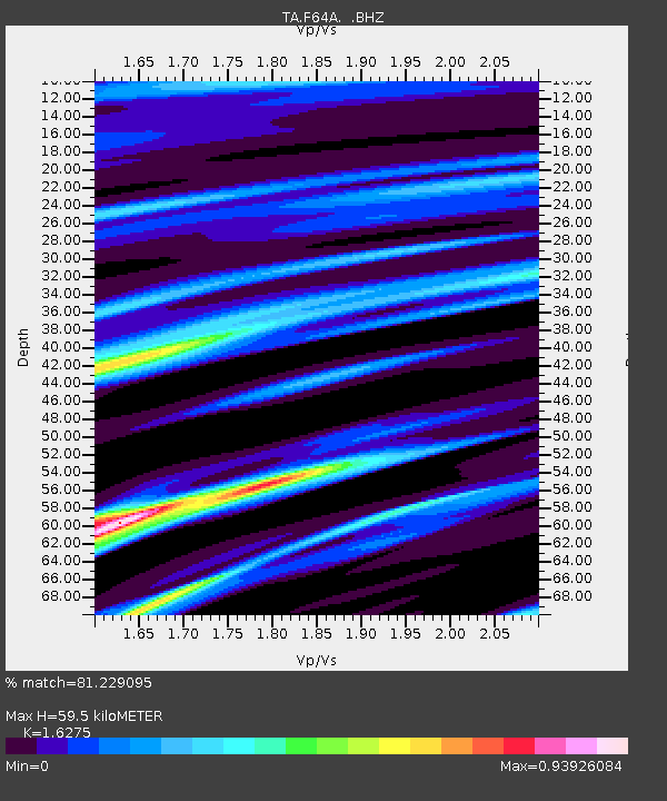
| Estimated Moho Depth: |
59.5 km |
| Estimated Crust Vp/Vs: |
1.63 |
| Assumed Crust Vp: |
6.419 km/s |
| Estimated Crust Vs: |
3.944 km/s |
| Estimated Crust Poisson's Ratio: |
0.20 |
|
| Radial Match: |
81.229095 % |
| Radial Bump: |
373 |
| Transverse Match: |
58.761 % |
| Transverse Bump: |
385 |
| SOD ConfigId: |
626651 |
| Insert Time: |
2014-04-20 19:11:59.763 +0000 |
| GWidth: |
2.5 |
| Max Bumps: |
400 |
| Tol: |
0.001 |
|

Signal To Noise
| Channel | StoN | STA | LTA |
| TA:F64A: :BHZ:20140218T09:33:08.975Z | 4.047189 | 3.1903944E-6 | 7.8829873E-7 |
| TA:F64A: :BHN:20140218T09:33:08.975Z | 2.7963762 | 1.8299008E-6 | 6.543829E-7 |
| TA:F64A: :BHE:20140218T09:33:08.975Z | 0.67490494 | 2.7732537E-7 | 4.1091025E-7 |
| Arrivals |
| Ps | 6.3 SECOND |
| PpPs | 22 SECOND |
| PsPs/PpSs | 29 SECOND |


