You are here: Home > Network List > TA - USArray Transportable Network (new EarthScope stations) Stations List
> Station G45A Suttons Bay, MI, USA > Earthquake Result Viewer
G45A Suttons Bay, MI, USA - Earthquake Result Viewer
| Earthquake location: |
North Atlantic Ocean |
| Earthquake latitude/longitude: |
14.7/-58.9 |
| Earthquake time(UTC): |
2014/02/18 (049) 09:27:13 GMT |
| Earthquake Depth: |
17 km |
| Earthquake Magnitude: |
6.5 MWW, 6.3 MWB, 6.5 MWC, 6.6 MWC, 6.7 MI |
| Earthquake Catalog/Contributor: |
NEIC PDE/NEIC COMCAT |
|
| Network: |
TA USArray Transportable Network (new EarthScope stations) |
| Station: |
G45A Suttons Bay, MI, USA |
| Lat/Lon: |
45.04 N/85.66 W |
| Elevation: |
284 m |
|
| Distance: |
37.8 deg |
| Az: |
328.651 deg |
| Baz: |
134.746 deg |
| Ray Param: |
0.07591394 |
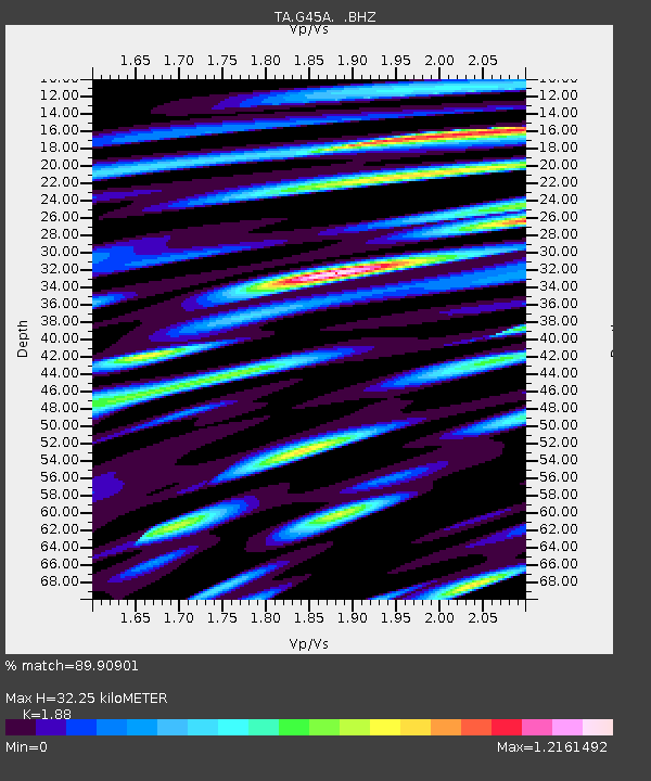
| Estimated Moho Depth: |
32.25 km |
| Estimated Crust Vp/Vs: |
1.88 |
| Assumed Crust Vp: |
6.483 km/s |
| Estimated Crust Vs: |
3.448 km/s |
| Estimated Crust Poisson's Ratio: |
0.30 |
|
| Radial Match: |
89.90901 % |
| Radial Bump: |
400 |
| Transverse Match: |
62.54846 % |
| Transverse Bump: |
400 |
| SOD ConfigId: |
626651 |
| Insert Time: |
2014-04-20 19:12:09.249 +0000 |
| GWidth: |
2.5 |
| Max Bumps: |
400 |
| Tol: |
0.001 |
|

Signal To Noise
| Channel | StoN | STA | LTA |
| TA:G45A: :BHZ:20140218T09:33:57.925012Z | 7.982382 | 2.6943512E-6 | 3.3753727E-7 |
| TA:G45A: :BHN:20140218T09:33:57.925012Z | 6.9056535 | 1.6394679E-6 | 2.3740952E-7 |
| TA:G45A: :BHE:20140218T09:33:57.925012Z | 5.1017118 | 2.062663E-6 | 4.0430803E-7 |
| Arrivals |
| Ps | 4.7 SECOND |
| PpPs | 13 SECOND |
| PsPs/PpSs | 18 SECOND |


