You are here: Home > Network List > TA - USArray Transportable Network (new EarthScope stations) Stations List
> Station G47A Hillman, MI, USA > Earthquake Result Viewer
G47A Hillman, MI, USA - Earthquake Result Viewer

| Earthquake location: |
North Atlantic Ocean |
| Earthquake latitude/longitude: |
14.7/-58.9 |
| Earthquake time(UTC): |
2014/02/18 (049) 09:27:13 GMT |
| Earthquake Depth: |
17 km |
| Earthquake Magnitude: |
6.5 MWW, 6.3 MWB, 6.5 MWC, 6.6 MWC, 6.7 MI |
| Earthquake Catalog/Contributor: |
NEIC PDE/NEIC COMCAT |
|
| Network: |
TA USArray Transportable Network (new EarthScope stations) |
| Station: |
G47A Hillman, MI, USA |
| Lat/Lon: |
45.17 N/83.86 W |
| Elevation: |
239 m |
|
| Distance: |
37.0 deg |
| Az: |
330.315 deg |
| Baz: |
137.34 deg |
| Ray Param: |
0.07635285 |
| Estimated Moho Depth: |
53.5 km |
| Estimated Crust Vp/Vs: |
2.10 |
| Assumed Crust Vp: |
6.483 km/s |
| Estimated Crust Vs: |
3.091 km/s |
| Estimated Crust Poisson's Ratio: |
0.35 |
|
| Radial Match: |
95.10267 % |
| Radial Bump: |
241 |
| Transverse Match: |
58.975967 % |
| Transverse Bump: |
400 |
| SOD ConfigId: |
626651 |
| Insert Time: |
2014-04-20 19:12:13.923 +0000 |
| GWidth: |
2.5 |
| Max Bumps: |
400 |
| Tol: |
0.001 |
|
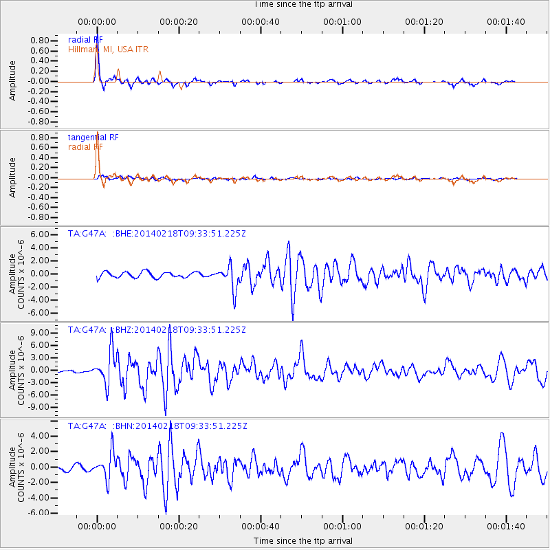
Signal To Noise
| Channel | StoN | STA | LTA |
| TA:G47A: :BHZ:20140218T09:33:51.225Z | 7.945415 | 4.139739E-6 | 5.2102234E-7 |
| TA:G47A: :BHN:20140218T09:33:51.225Z | 5.039168 | 1.7626337E-6 | 3.4978666E-7 |
| TA:G47A: :BHE:20140218T09:33:51.225Z | 4.295168 | 1.8771161E-6 | 4.3702974E-7 |
| Arrivals |
| Ps | 9.7 SECOND |
| PpPs | 24 SECOND |
| PsPs/PpSs | 34 SECOND |


