You are here: Home > Network List > TA - USArray Transportable Network (new EarthScope stations) Stations List
> Station G61A St-Isidore-de-Clifton, QC, USA > Earthquake Result Viewer
G61A St-Isidore-de-Clifton, QC, USA - Earthquake Result Viewer
| Earthquake location: |
North Atlantic Ocean |
| Earthquake latitude/longitude: |
14.7/-58.9 |
| Earthquake time(UTC): |
2014/02/18 (049) 09:27:13 GMT |
| Earthquake Depth: |
17 km |
| Earthquake Magnitude: |
6.5 MWW, 6.3 MWB, 6.5 MWC, 6.6 MWC, 6.7 MI |
| Earthquake Catalog/Contributor: |
NEIC PDE/NEIC COMCAT |
|
| Network: |
TA USArray Transportable Network (new EarthScope stations) |
| Station: |
G61A St-Isidore-de-Clifton, QC, USA |
| Lat/Lon: |
45.28 N/71.53 W |
| Elevation: |
378 m |
|
| Distance: |
32.3 deg |
| Az: |
343.271 deg |
| Baz: |
156.758 deg |
| Ray Param: |
0.07867984 |
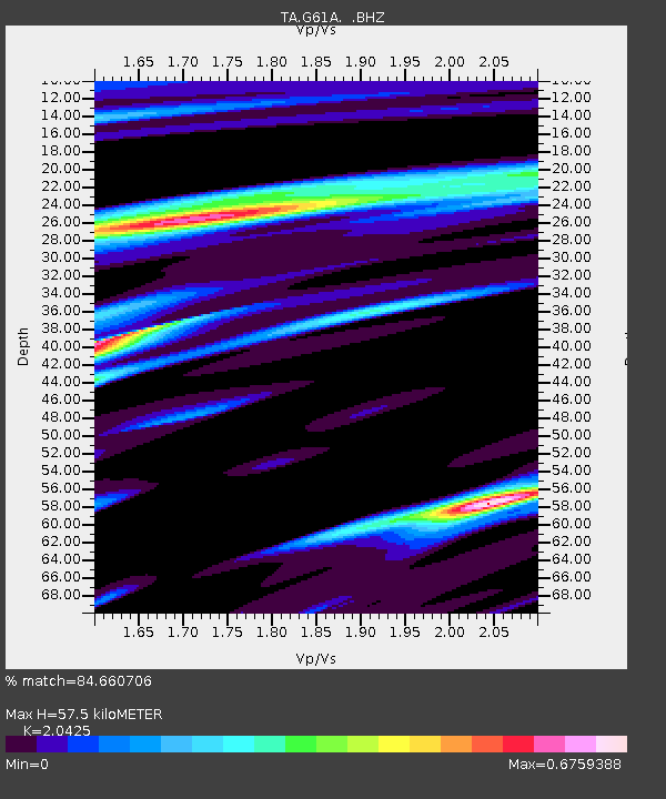
| Estimated Moho Depth: |
57.5 km |
| Estimated Crust Vp/Vs: |
2.04 |
| Assumed Crust Vp: |
6.419 km/s |
| Estimated Crust Vs: |
3.143 km/s |
| Estimated Crust Poisson's Ratio: |
0.34 |
|
| Radial Match: |
84.660706 % |
| Radial Bump: |
357 |
| Transverse Match: |
59.260815 % |
| Transverse Bump: |
400 |
| SOD ConfigId: |
626651 |
| Insert Time: |
2014-04-20 19:12:37.296 +0000 |
| GWidth: |
2.5 |
| Max Bumps: |
400 |
| Tol: |
0.001 |
|

Signal To Noise
| Channel | StoN | STA | LTA |
| TA:G61A: :BHZ:20140218T09:33:10.999994Z | 6.070175 | 3.4792388E-6 | 5.731694E-7 |
| TA:G61A: :BHN:20140218T09:33:10.999994Z | 4.678035 | 1.5520986E-6 | 3.3178432E-7 |
| TA:G61A: :BHE:20140218T09:33:10.999994Z | 1.5322379 | 7.1998033E-7 | 4.6988808E-7 |
| Arrivals |
| Ps | 10.0 SECOND |
| PpPs | 25 SECOND |
| PsPs/PpSs | 35 SECOND |


