You are here: Home > Network List > TA - USArray Transportable Network (new EarthScope stations) Stations List
> Station H48A Harrisville, MI, USA > Earthquake Result Viewer
H48A Harrisville, MI, USA - Earthquake Result Viewer

| Earthquake location: |
North Atlantic Ocean |
| Earthquake latitude/longitude: |
14.7/-58.9 |
| Earthquake time(UTC): |
2014/02/18 (049) 09:27:13 GMT |
| Earthquake Depth: |
17 km |
| Earthquake Magnitude: |
6.5 MWW, 6.3 MWB, 6.5 MWC, 6.6 MWC, 6.7 MI |
| Earthquake Catalog/Contributor: |
NEIC PDE/NEIC COMCAT |
|
| Network: |
TA USArray Transportable Network (new EarthScope stations) |
| Station: |
H48A Harrisville, MI, USA |
| Lat/Lon: |
44.70 N/83.32 W |
| Elevation: |
244 m |
|
| Distance: |
36.4 deg |
| Az: |
330.246 deg |
| Baz: |
137.657 deg |
| Ray Param: |
0.07668108 |
| Estimated Moho Depth: |
27.75 km |
| Estimated Crust Vp/Vs: |
2.02 |
| Assumed Crust Vp: |
6.483 km/s |
| Estimated Crust Vs: |
3.205 km/s |
| Estimated Crust Poisson's Ratio: |
0.34 |
|
| Radial Match: |
86.59504 % |
| Radial Bump: |
400 |
| Transverse Match: |
67.75674 % |
| Transverse Bump: |
400 |
| SOD ConfigId: |
626651 |
| Insert Time: |
2014-04-20 19:13:04.734 +0000 |
| GWidth: |
2.5 |
| Max Bumps: |
400 |
| Tol: |
0.001 |
|
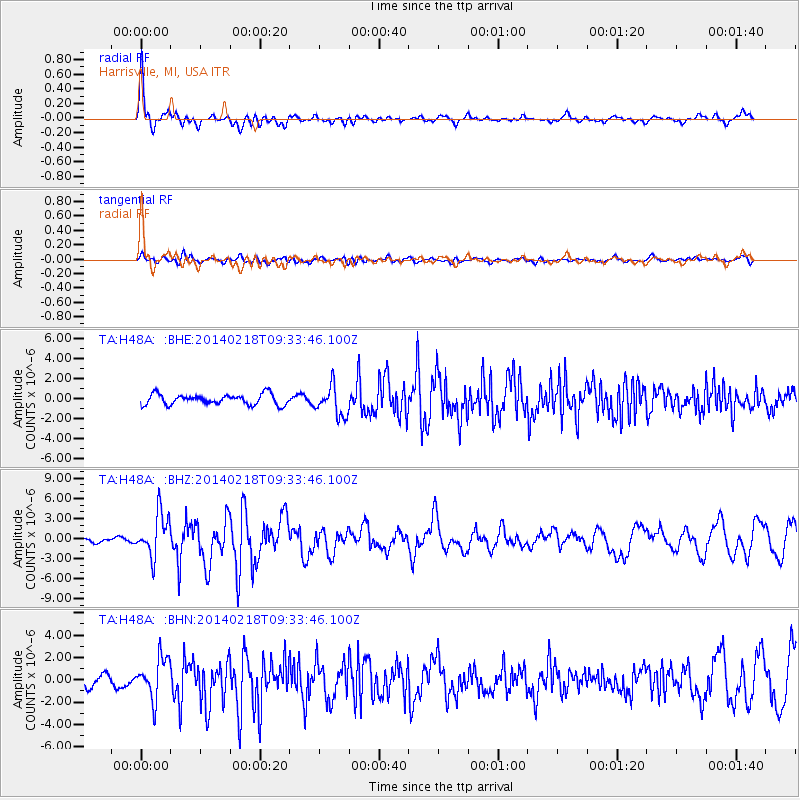
Signal To Noise
| Channel | StoN | STA | LTA |
| TA:H48A: :BHZ:20140218T09:33:46.100Z | 4.3759255 | 3.1978013E-6 | 7.3077143E-7 |
| TA:H48A: :BHN:20140218T09:33:46.100Z | 2.4915922 | 1.8673537E-6 | 7.49462E-7 |
| TA:H48A: :BHE:20140218T09:33:46.100Z | 2.847223 | 1.4933191E-6 | 5.244827E-7 |
| Arrivals |
| Ps | 4.7 SECOND |
| PpPs | 12 SECOND |
| PsPs/PpSs | 17 SECOND |


