You are here: Home > Network List > TA - USArray Transportable Network (new EarthScope stations) Stations List
> Station H58A Gabriels, NY, USA > Earthquake Result Viewer
H58A Gabriels, NY, USA - Earthquake Result Viewer
| Earthquake location: |
North Atlantic Ocean |
| Earthquake latitude/longitude: |
14.7/-58.9 |
| Earthquake time(UTC): |
2014/02/18 (049) 09:27:13 GMT |
| Earthquake Depth: |
17 km |
| Earthquake Magnitude: |
6.5 MWW, 6.3 MWB, 6.5 MWC, 6.6 MWC, 6.7 MI |
| Earthquake Catalog/Contributor: |
NEIC PDE/NEIC COMCAT |
|
| Network: |
TA USArray Transportable Network (new EarthScope stations) |
| Station: |
H58A Gabriels, NY, USA |
| Lat/Lon: |
44.42 N/74.18 W |
| Elevation: |
537 m |
|
| Distance: |
32.4 deg |
| Az: |
339.394 deg |
| Baz: |
151.618 deg |
| Ray Param: |
0.07866157 |
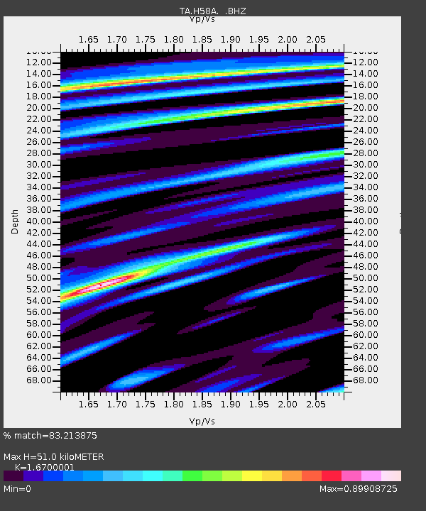
| Estimated Moho Depth: |
51.0 km |
| Estimated Crust Vp/Vs: |
1.67 |
| Assumed Crust Vp: |
6.419 km/s |
| Estimated Crust Vs: |
3.844 km/s |
| Estimated Crust Poisson's Ratio: |
0.22 |
|
| Radial Match: |
83.213875 % |
| Radial Bump: |
377 |
| Transverse Match: |
49.598866 % |
| Transverse Bump: |
400 |
| SOD ConfigId: |
626651 |
| Insert Time: |
2014-04-20 19:13:21.642 +0000 |
| GWidth: |
2.5 |
| Max Bumps: |
400 |
| Tol: |
0.001 |
|

Signal To Noise
| Channel | StoN | STA | LTA |
| TA:H58A: :BHZ:20140218T09:33:11.374994Z | 4.162103 | 1.9118918E-6 | 4.593571E-7 |
| TA:H58A: :BHN:20140218T09:33:11.374994Z | 5.3827534 | 1.3331514E-6 | 2.476709E-7 |
| TA:H58A: :BHE:20140218T09:33:11.374994Z | 2.1364343 | 6.167068E-7 | 2.8866174E-7 |
| Arrivals |
| Ps | 5.8 SECOND |
| PpPs | 20 SECOND |
| PsPs/PpSs | 25 SECOND |


