You are here: Home > Network List > TA - USArray Transportable Network (new EarthScope stations) Stations List
> Station I55A Frankford, ON, CAN > Earthquake Result Viewer
I55A Frankford, ON, CAN - Earthquake Result Viewer
| Earthquake location: |
North Atlantic Ocean |
| Earthquake latitude/longitude: |
14.7/-58.9 |
| Earthquake time(UTC): |
2014/02/18 (049) 09:27:13 GMT |
| Earthquake Depth: |
17 km |
| Earthquake Magnitude: |
6.5 MWW, 6.3 MWB, 6.5 MWC, 6.6 MWC, 6.7 MI |
| Earthquake Catalog/Contributor: |
NEIC PDE/NEIC COMCAT |
|
| Network: |
TA USArray Transportable Network (new EarthScope stations) |
| Station: |
I55A Frankford, ON, CAN |
| Lat/Lon: |
44.22 N/77.68 W |
| Elevation: |
132 m |
|
| Distance: |
33.5 deg |
| Az: |
335.254 deg |
| Baz: |
145.705 deg |
| Ray Param: |
0.078155704 |
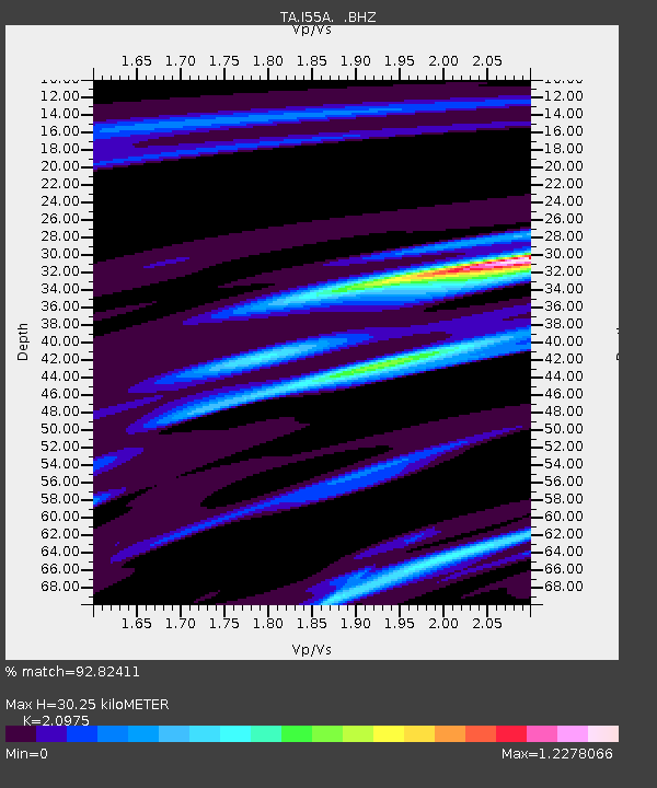
| Estimated Moho Depth: |
30.25 km |
| Estimated Crust Vp/Vs: |
2.10 |
| Assumed Crust Vp: |
6.577 km/s |
| Estimated Crust Vs: |
3.136 km/s |
| Estimated Crust Poisson's Ratio: |
0.35 |
|
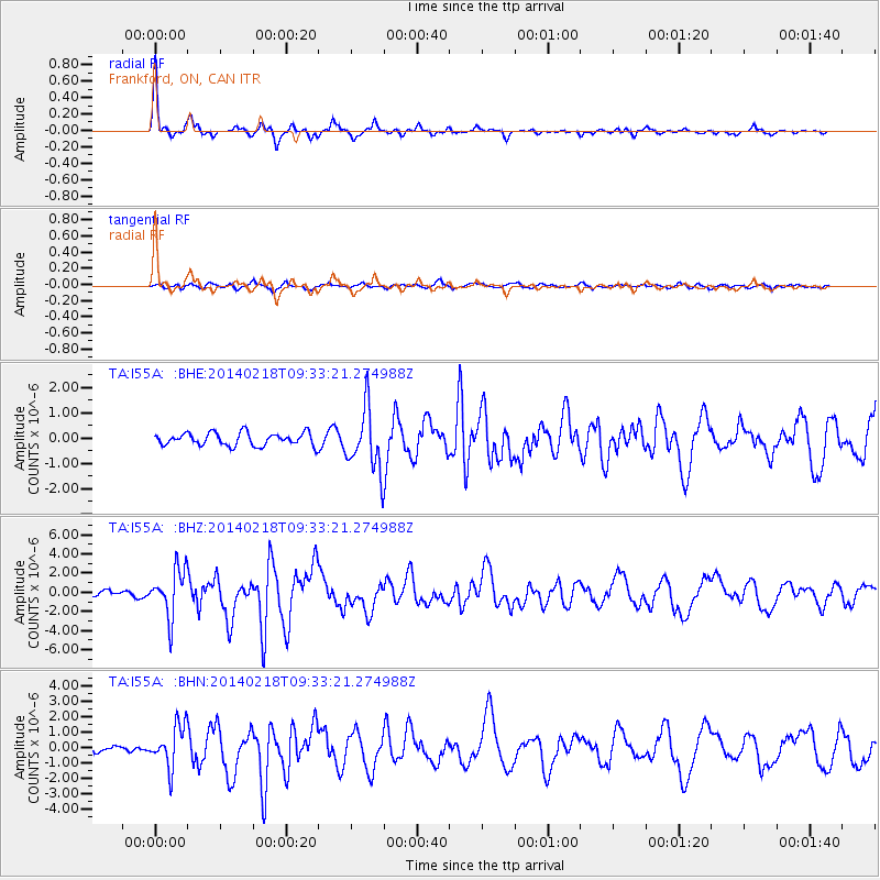
| Radial Match: |
92.82411 % |
| Radial Bump: |
299 |
| Transverse Match: |
67.84373 % |
| Transverse Bump: |
400 |
| SOD ConfigId: |
626651 |
| Insert Time: |
2014-04-20 19:14:18.281 +0000 |
| GWidth: |
2.5 |
| Max Bumps: |
400 |
| Tol: |
0.001 |
|
Signal To Noise
| Channel | StoN | STA | LTA |
| TA:I55A: :BHZ:20140218T09:33:21.274988Z | 5.43837 | 2.4771966E-6 | 4.5550348E-7 |
| TA:I55A: :BHN:20140218T09:33:21.274988Z | 4.9372373 | 1.3494273E-6 | 2.733163E-7 |
| TA:I55A: :BHE:20140218T09:33:21.274988Z | 4.801718 | 1.2180743E-6 | 2.5367467E-7 |
| Arrivals |
| Ps | 5.4 SECOND |
| PpPs | 13 SECOND |
| PsPs/PpSs | 19 SECOND |


