You are here: Home > Network List > TA - USArray Transportable Network (new EarthScope stations) Stations List
> Station I59A Olmsteadville, NY, USA > Earthquake Result Viewer
I59A Olmsteadville, NY, USA - Earthquake Result Viewer
| Earthquake location: |
North Atlantic Ocean |
| Earthquake latitude/longitude: |
14.7/-58.9 |
| Earthquake time(UTC): |
2014/02/18 (049) 09:27:13 GMT |
| Earthquake Depth: |
17 km |
| Earthquake Magnitude: |
6.5 MWW, 6.3 MWB, 6.5 MWC, 6.6 MWC, 6.7 MI |
| Earthquake Catalog/Contributor: |
NEIC PDE/NEIC COMCAT |
|
| Network: |
TA USArray Transportable Network (new EarthScope stations) |
| Station: |
I59A Olmsteadville, NY, USA |
| Lat/Lon: |
43.80 N/73.87 W |
| Elevation: |
390 m |
|
| Distance: |
31.7 deg |
| Az: |
339.203 deg |
| Baz: |
151.667 deg |
| Ray Param: |
0.078938626 |
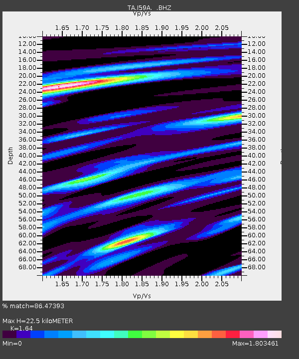
| Estimated Moho Depth: |
22.5 km |
| Estimated Crust Vp/Vs: |
1.64 |
| Assumed Crust Vp: |
6.419 km/s |
| Estimated Crust Vs: |
3.914 km/s |
| Estimated Crust Poisson's Ratio: |
0.20 |
|
| Radial Match: |
86.47393 % |
| Radial Bump: |
388 |
| Transverse Match: |
75.6402 % |
| Transverse Bump: |
400 |
| SOD ConfigId: |
626651 |
| Insert Time: |
2014-04-20 19:14:24.552 +0000 |
| GWidth: |
2.5 |
| Max Bumps: |
400 |
| Tol: |
0.001 |
|

Signal To Noise
| Channel | StoN | STA | LTA |
| TA:I59A: :BHZ:20140218T09:33:05.675012Z | 5.296671 | 2.0712253E-6 | 3.9104285E-7 |
| TA:I59A: :BHN:20140218T09:33:05.675012Z | 5.2642226 | 1.4593548E-6 | 2.7722135E-7 |
| TA:I59A: :BHE:20140218T09:33:05.675012Z | 2.5725114 | 9.24243E-7 | 3.5927653E-7 |
| Arrivals |
| Ps | 2.4 SECOND |
| PpPs | 8.5 SECOND |
| PsPs/PpSs | 11 SECOND |


