You are here: Home > Network List > TA - USArray Transportable Network (new EarthScope stations) Stations List
> Station J46A Howard City, MI, USA > Earthquake Result Viewer
J46A Howard City, MI, USA - Earthquake Result Viewer
| Earthquake location: |
North Atlantic Ocean |
| Earthquake latitude/longitude: |
14.7/-58.9 |
| Earthquake time(UTC): |
2014/02/18 (049) 09:27:13 GMT |
| Earthquake Depth: |
17 km |
| Earthquake Magnitude: |
6.5 MWW, 6.3 MWB, 6.5 MWC, 6.6 MWC, 6.7 MI |
| Earthquake Catalog/Contributor: |
NEIC PDE/NEIC COMCAT |
|
| Network: |
TA USArray Transportable Network (new EarthScope stations) |
| Station: |
J46A Howard City, MI, USA |
| Lat/Lon: |
43.35 N/85.65 W |
| Elevation: |
275 m |
|
| Distance: |
36.6 deg |
| Az: |
326.645 deg |
| Baz: |
133.155 deg |
| Ray Param: |
0.07656508 |
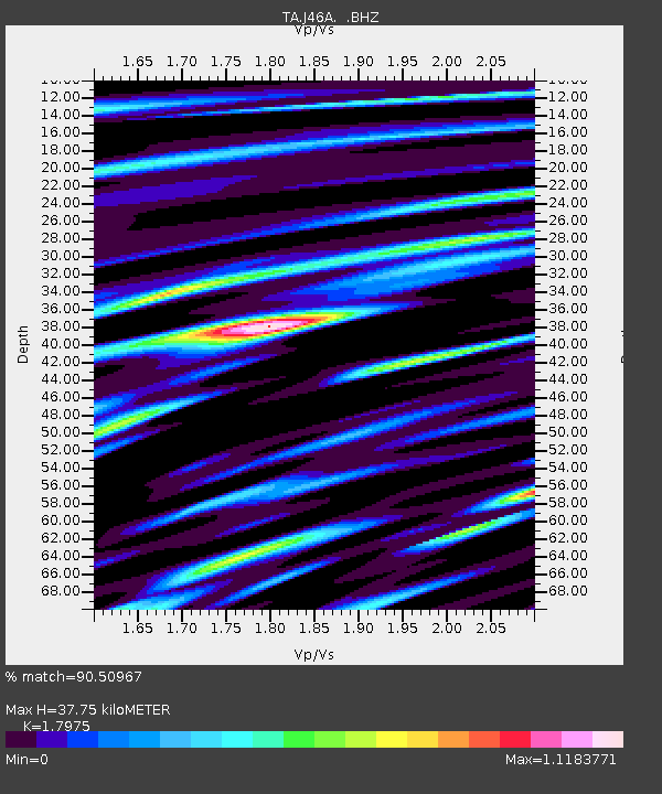
| Estimated Moho Depth: |
37.75 km |
| Estimated Crust Vp/Vs: |
1.80 |
| Assumed Crust Vp: |
6.483 km/s |
| Estimated Crust Vs: |
3.606 km/s |
| Estimated Crust Poisson's Ratio: |
0.28 |
|
| Radial Match: |
90.50967 % |
| Radial Bump: |
400 |
| Transverse Match: |
70.79124 % |
| Transverse Bump: |
400 |
| SOD ConfigId: |
626651 |
| Insert Time: |
2014-04-20 19:14:53.748 +0000 |
| GWidth: |
2.5 |
| Max Bumps: |
400 |
| Tol: |
0.001 |
|

Signal To Noise
| Channel | StoN | STA | LTA |
| TA:J46A: :BHZ:20140218T09:33:47.925012Z | 7.448321 | 3.7928457E-6 | 5.092216E-7 |
| TA:J46A: :BHN:20140218T09:33:47.925012Z | 3.1602798 | 1.8897147E-6 | 5.9795804E-7 |
| TA:J46A: :BHE:20140218T09:33:47.925012Z | 4.4675293 | 2.1525855E-6 | 4.8182903E-7 |
| Arrivals |
| Ps | 5.0 SECOND |
| PpPs | 15 SECOND |
| PsPs/PpSs | 20 SECOND |


