You are here: Home > Network List > TA - USArray Transportable Network (new EarthScope stations) Stations List
> Station J47A Sunmer, MI, USA > Earthquake Result Viewer
J47A Sunmer, MI, USA - Earthquake Result Viewer
| Earthquake location: |
North Atlantic Ocean |
| Earthquake latitude/longitude: |
14.7/-58.9 |
| Earthquake time(UTC): |
2014/02/18 (049) 09:27:13 GMT |
| Earthquake Depth: |
17 km |
| Earthquake Magnitude: |
6.5 MWW, 6.3 MWB, 6.5 MWC, 6.6 MWC, 6.7 MI |
| Earthquake Catalog/Contributor: |
NEIC PDE/NEIC COMCAT |
|
| Network: |
TA USArray Transportable Network (new EarthScope stations) |
| Station: |
J47A Sunmer, MI, USA |
| Lat/Lon: |
43.24 N/84.82 W |
| Elevation: |
236 m |
|
| Distance: |
36.1 deg |
| Az: |
327.213 deg |
| Baz: |
134.176 deg |
| Ray Param: |
0.076843634 |
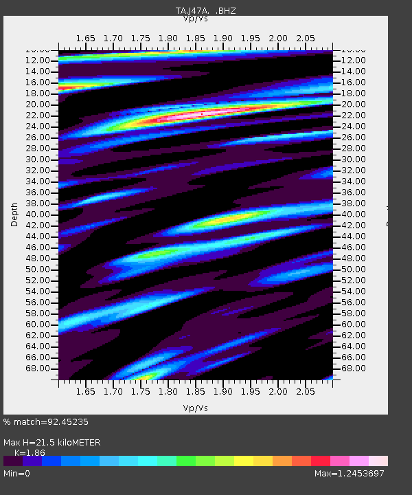
| Estimated Moho Depth: |
21.5 km |
| Estimated Crust Vp/Vs: |
1.86 |
| Assumed Crust Vp: |
6.483 km/s |
| Estimated Crust Vs: |
3.485 km/s |
| Estimated Crust Poisson's Ratio: |
0.30 |
|
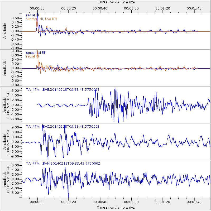
| Radial Match: |
92.45235 % |
| Radial Bump: |
400 |
| Transverse Match: |
74.09241 % |
| Transverse Bump: |
400 |
| SOD ConfigId: |
626651 |
| Insert Time: |
2014-04-20 19:14:58.574 +0000 |
| GWidth: |
2.5 |
| Max Bumps: |
400 |
| Tol: |
0.001 |
|
Signal To Noise
| Channel | StoN | STA | LTA |
| TA:J47A: :BHZ:20140218T09:33:43.575006Z | 7.042796 | 3.9290903E-6 | 5.578878E-7 |
| TA:J47A: :BHN:20140218T09:33:43.575006Z | 2.1664588 | 1.6592031E-6 | 7.658595E-7 |
| TA:J47A: :BHE:20140218T09:33:43.575006Z | 4.1408553 | 1.6423508E-6 | 3.9662112E-7 |
| Arrivals |
| Ps | 3.1 SECOND |
| PpPs | 8.8 SECOND |
| PsPs/PpSs | 12 SECOND |


