You are here: Home > Network List > TA - USArray Transportable Network (new EarthScope stations) Stations List
> Station J49A Marlette, MI, USA > Earthquake Result Viewer
J49A Marlette, MI, USA - Earthquake Result Viewer
| Earthquake location: |
North Atlantic Ocean |
| Earthquake latitude/longitude: |
14.7/-58.9 |
| Earthquake time(UTC): |
2014/02/18 (049) 09:27:13 GMT |
| Earthquake Depth: |
17 km |
| Earthquake Magnitude: |
6.5 MWW, 6.3 MWB, 6.5 MWC, 6.6 MWC, 6.7 MI |
| Earthquake Catalog/Contributor: |
NEIC PDE/NEIC COMCAT |
|
| Network: |
TA USArray Transportable Network (new EarthScope stations) |
| Station: |
J49A Marlette, MI, USA |
| Lat/Lon: |
43.36 N/83.14 W |
| Elevation: |
253 m |
|
| Distance: |
35.3 deg |
| Az: |
328.858 deg |
| Baz: |
136.662 deg |
| Ray Param: |
0.077263206 |
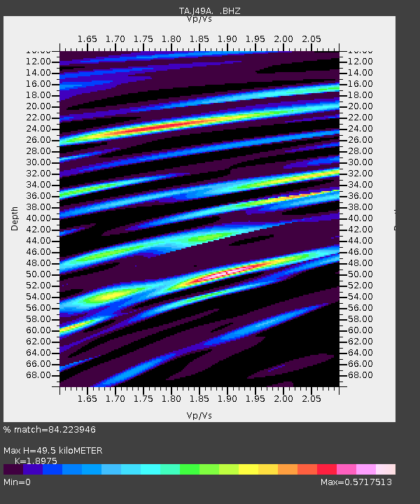
| Estimated Moho Depth: |
49.5 km |
| Estimated Crust Vp/Vs: |
1.90 |
| Assumed Crust Vp: |
6.483 km/s |
| Estimated Crust Vs: |
3.416 km/s |
| Estimated Crust Poisson's Ratio: |
0.31 |
|
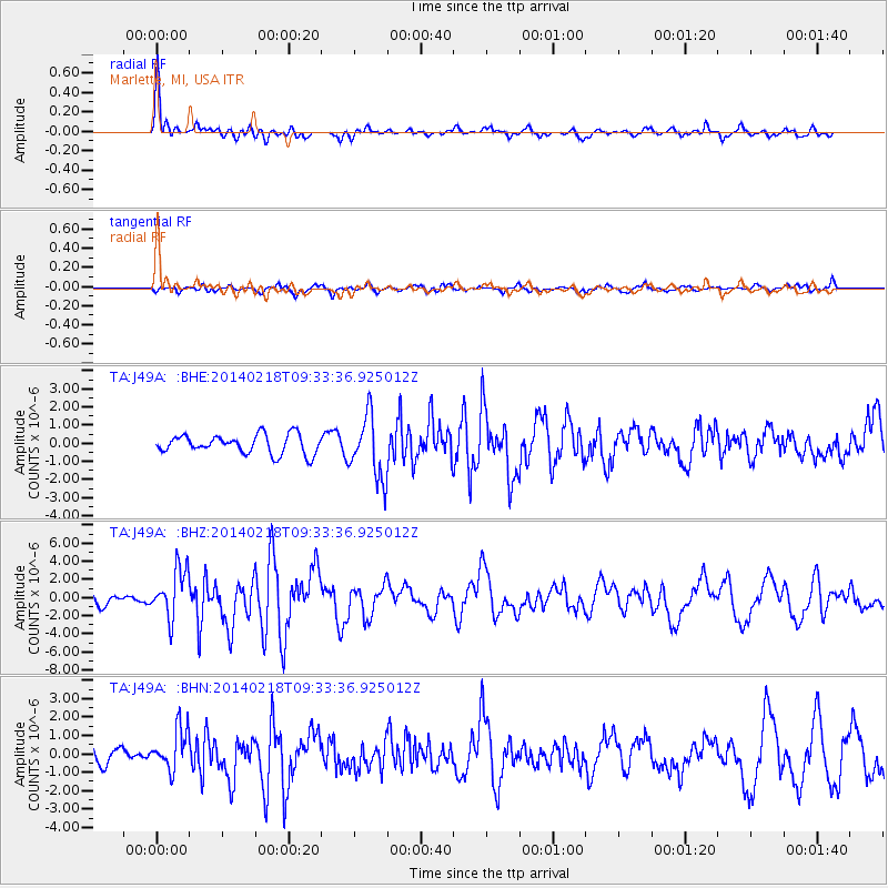
| Radial Match: |
84.223946 % |
| Radial Bump: |
362 |
| Transverse Match: |
68.12678 % |
| Transverse Bump: |
400 |
| SOD ConfigId: |
626651 |
| Insert Time: |
2014-04-20 19:15:05.542 +0000 |
| GWidth: |
2.5 |
| Max Bumps: |
400 |
| Tol: |
0.001 |
|
Signal To Noise
| Channel | StoN | STA | LTA |
| TA:J49A: :BHZ:20140218T09:33:36.925012Z | 5.430664 | 2.7166986E-6 | 5.0025164E-7 |
| TA:J49A: :BHN:20140218T09:33:36.925012Z | 1.5521106 | 1.1382677E-6 | 7.333677E-7 |
| TA:J49A: :BHE:20140218T09:33:36.925012Z | 3.302237 | 1.7203745E-6 | 5.2097243E-7 |
| Arrivals |
| Ps | 7.4 SECOND |
| PpPs | 21 SECOND |
| PsPs/PpSs | 28 SECOND |


