You are here: Home > Network List > TA - USArray Transportable Network (new EarthScope stations) Stations List
> Station J55A Hilton, NY, USA > Earthquake Result Viewer
J55A Hilton, NY, USA - Earthquake Result Viewer
| Earthquake location: |
North Atlantic Ocean |
| Earthquake latitude/longitude: |
14.7/-58.9 |
| Earthquake time(UTC): |
2014/02/18 (049) 09:27:13 GMT |
| Earthquake Depth: |
17 km |
| Earthquake Magnitude: |
6.5 MWW, 6.3 MWB, 6.5 MWC, 6.6 MWC, 6.7 MI |
| Earthquake Catalog/Contributor: |
NEIC PDE/NEIC COMCAT |
|
| Network: |
TA USArray Transportable Network (new EarthScope stations) |
| Station: |
J55A Hilton, NY, USA |
| Lat/Lon: |
43.27 N/77.82 W |
| Elevation: |
97 m |
|
| Distance: |
32.8 deg |
| Az: |
334.115 deg |
| Baz: |
144.658 deg |
| Ray Param: |
0.07848648 |
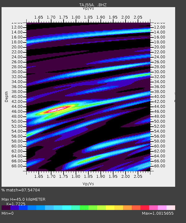
| Estimated Moho Depth: |
45.0 km |
| Estimated Crust Vp/Vs: |
1.72 |
| Assumed Crust Vp: |
6.476 km/s |
| Estimated Crust Vs: |
3.76 km/s |
| Estimated Crust Poisson's Ratio: |
0.25 |
|
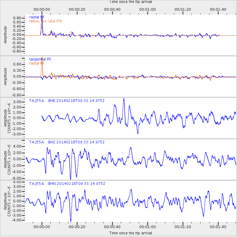
| Radial Match: |
87.54784 % |
| Radial Bump: |
362 |
| Transverse Match: |
64.16448 % |
| Transverse Bump: |
400 |
| SOD ConfigId: |
626651 |
| Insert Time: |
2014-04-20 19:15:10.782 +0000 |
| GWidth: |
2.5 |
| Max Bumps: |
400 |
| Tol: |
0.001 |
|
Signal To Noise
| Channel | StoN | STA | LTA |
| TA:J55A: :BHZ:20140218T09:33:14.975Z | 5.3113875 | 2.0880384E-6 | 3.9312485E-7 |
| TA:J55A: :BHN:20140218T09:33:14.975Z | 2.2550395 | 1.2042482E-6 | 5.3402533E-7 |
| TA:J55A: :BHE:20140218T09:33:14.975Z | 2.1699827 | 8.085577E-7 | 3.726102E-7 |
| Arrivals |
| Ps | 5.5 SECOND |
| PpPs | 17 SECOND |
| PsPs/PpSs | 23 SECOND |


