You are here: Home > Network List > TA - USArray Transportable Network (new EarthScope stations) Stations List
> Station J59A Piesco, NY, USA > Earthquake Result Viewer
J59A Piesco, NY, USA - Earthquake Result Viewer
| Earthquake location: |
North Atlantic Ocean |
| Earthquake latitude/longitude: |
14.7/-58.9 |
| Earthquake time(UTC): |
2014/02/18 (049) 09:27:13 GMT |
| Earthquake Depth: |
17 km |
| Earthquake Magnitude: |
6.5 MWW, 6.3 MWB, 6.5 MWC, 6.6 MWC, 6.7 MI |
| Earthquake Catalog/Contributor: |
NEIC PDE/NEIC COMCAT |
|
| Network: |
TA USArray Transportable Network (new EarthScope stations) |
| Station: |
J59A Piesco, NY, USA |
| Lat/Lon: |
43.46 N/74.50 W |
| Elevation: |
541 m |
|
| Distance: |
31.7 deg |
| Az: |
338.136 deg |
| Baz: |
150.327 deg |
| Ray Param: |
0.07896741 |
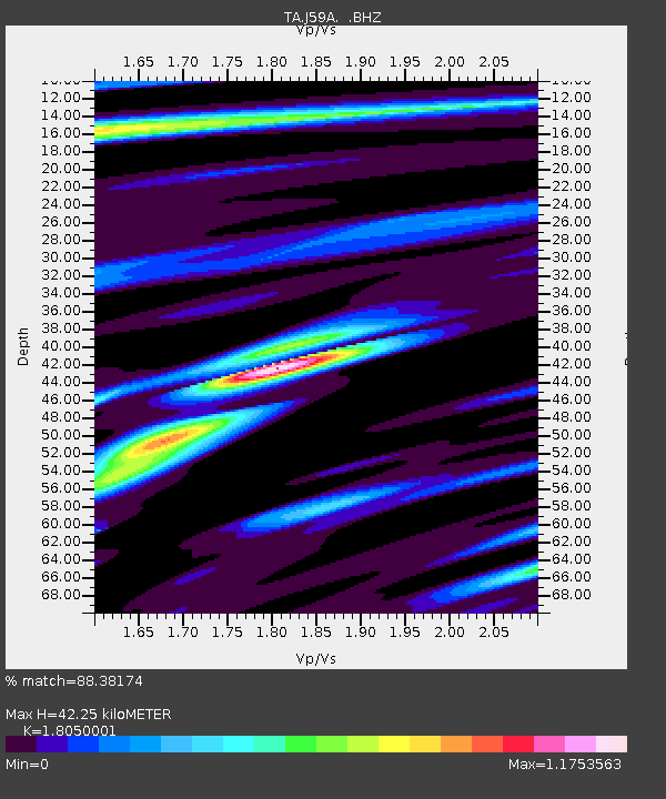
| Estimated Moho Depth: |
42.25 km |
| Estimated Crust Vp/Vs: |
1.81 |
| Assumed Crust Vp: |
6.419 km/s |
| Estimated Crust Vs: |
3.556 km/s |
| Estimated Crust Poisson's Ratio: |
0.28 |
|
| Radial Match: |
88.38174 % |
| Radial Bump: |
358 |
| Transverse Match: |
75.282166 % |
| Transverse Bump: |
400 |
| SOD ConfigId: |
626651 |
| Insert Time: |
2014-04-20 19:15:23.475 +0000 |
| GWidth: |
2.5 |
| Max Bumps: |
400 |
| Tol: |
0.001 |
|

Signal To Noise
| Channel | StoN | STA | LTA |
| TA:J59A: :BHZ:20140218T09:33:05.075006Z | 4.476838 | 2.1189774E-6 | 4.733201E-7 |
| TA:J59A: :BHN:20140218T09:33:05.075006Z | 4.5587554 | 1.3336568E-6 | 2.9254844E-7 |
| TA:J59A: :BHE:20140218T09:33:05.075006Z | 2.5545895 | 9.5111307E-7 | 3.723154E-7 |
| Arrivals |
| Ps | 5.7 SECOND |
| PpPs | 17 SECOND |
| PsPs/PpSs | 23 SECOND |


