You are here: Home > Network List > KN - Kyrgyz Seismic Telemetry Network Stations List
> Station TKM2 - > Earthquake Result Viewer
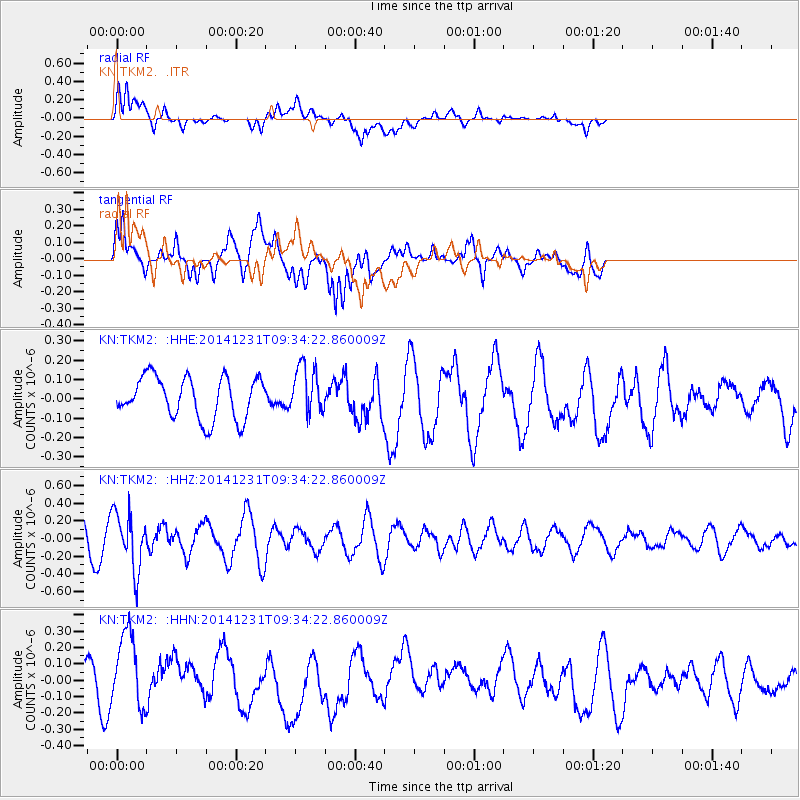
TKM2 - - Earthquake Result Viewer
*The percent match for this event was below the threshold and hence no stack was calculated.
| Earthquake location: |
Mindoro, Philippines |
| Earthquake latitude/longitude: |
13.8/120.7 |
| Earthquake time(UTC): |
2014/12/31 (365) 09:26:25 GMT |
| Earthquake Depth: |
134 km |
| Earthquake Magnitude: |
5.5 MW, 3.9 ms1mx, 4.1 Ms1, 4.1 MS, 5.0 mbtmp, 4.6 mb1mx, 4.7 mb1, 4.7 mb |
| Earthquake Catalog/Contributor: |
ISC/ISC |
|
| Network: |
KN Kyrgyz Seismic Telemetry Network |
| Station: |
TKM2 - |
| Lat/Lon: |
42.92 N/75.60 E |
| Elevation: |
2020 m |
|
| Distance: |
48.4 deg |
| Az: |
315.878 deg |
| Baz: |
112.948 deg |
| Ray Param: |
$rayparam |
*The percent match for this event was below the threshold and hence was not used in the summary stack. |
|
| Radial Match: |
56.55241 % |
| Radial Bump: |
400 |
| Transverse Match: |
70.29807 % |
| Transverse Bump: |
400 |
| SOD ConfigId: |
3390531 |
| Insert Time: |
2019-04-15 21:45:16.039 +0000 |
| GWidth: |
2.5 |
| Max Bumps: |
400 |
| Tol: |
0.001 |
|
Signal To Noise
| Channel | StoN | STA | LTA |
| KN:TKM2: :HHZ:20141231T09:34:22.860009Z | 1.8965248 | 3.222706E-7 | 1.6992692E-7 |
| KN:TKM2: :HHN:20141231T09:34:22.860009Z | 1.6908479 | 2.4277634E-7 | 1.435826E-7 |
| KN:TKM2: :HHE:20141231T09:34:22.860009Z | 1.1581703 | 1.2400375E-7 | 1.0706866E-7 |
| Arrivals |
| Ps | |
| PpPs | |
| PsPs/PpSs | |


