You are here: Home > Network List > TA - USArray Transportable Network (new EarthScope stations) Stations List
> Station K59A Cooperstown, NY, USA > Earthquake Result Viewer
K59A Cooperstown, NY, USA - Earthquake Result Viewer
| Earthquake location: |
North Atlantic Ocean |
| Earthquake latitude/longitude: |
14.7/-58.9 |
| Earthquake time(UTC): |
2014/02/18 (049) 09:27:13 GMT |
| Earthquake Depth: |
17 km |
| Earthquake Magnitude: |
6.5 MWW, 6.3 MWB, 6.5 MWC, 6.6 MWC, 6.7 MI |
| Earthquake Catalog/Contributor: |
NEIC PDE/NEIC COMCAT |
|
| Network: |
TA USArray Transportable Network (new EarthScope stations) |
| Station: |
K59A Cooperstown, NY, USA |
| Lat/Lon: |
42.78 N/74.85 W |
| Elevation: |
570 m |
|
| Distance: |
31.2 deg |
| Az: |
337.048 deg |
| Baz: |
149.161 deg |
| Ray Param: |
0.07912431 |
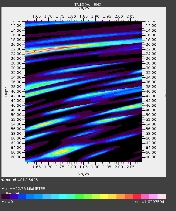
| Estimated Moho Depth: |
22.75 km |
| Estimated Crust Vp/Vs: |
1.64 |
| Assumed Crust Vp: |
6.419 km/s |
| Estimated Crust Vs: |
3.914 km/s |
| Estimated Crust Poisson's Ratio: |
0.20 |
|
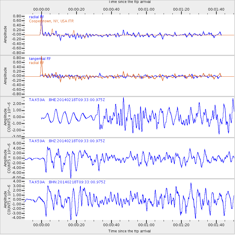
| Radial Match: |
81.16426 % |
| Radial Bump: |
400 |
| Transverse Match: |
69.75895 % |
| Transverse Bump: |
400 |
| SOD ConfigId: |
626651 |
| Insert Time: |
2014-04-20 19:16:19.953 +0000 |
| GWidth: |
2.5 |
| Max Bumps: |
400 |
| Tol: |
0.001 |
|
Signal To Noise
| Channel | StoN | STA | LTA |
| TA:K59A: :BHZ:20140218T09:33:00.975Z | 7.7784185 | 2.7212016E-6 | 3.4983992E-7 |
| TA:K59A: :BHN:20140218T09:33:00.975Z | 6.3222165 | 1.7387556E-6 | 2.750231E-7 |
| TA:K59A: :BHE:20140218T09:33:00.975Z | 1.8382933 | 1.0225268E-6 | 5.5623707E-7 |
| Arrivals |
| Ps | 2.5 SECOND |
| PpPs | 8.6 SECOND |
| PsPs/PpSs | 11 SECOND |


