You are here: Home > Network List > TA - USArray Transportable Network (new EarthScope stations) Stations List
> Station K62A Royalston, MA, USA > Earthquake Result Viewer
K62A Royalston, MA, USA - Earthquake Result Viewer

| Earthquake location: |
North Atlantic Ocean |
| Earthquake latitude/longitude: |
14.7/-58.9 |
| Earthquake time(UTC): |
2014/02/18 (049) 09:27:13 GMT |
| Earthquake Depth: |
17 km |
| Earthquake Magnitude: |
6.5 MWW, 6.3 MWB, 6.5 MWC, 6.6 MWC, 6.7 MI |
| Earthquake Catalog/Contributor: |
NEIC PDE/NEIC COMCAT |
|
| Network: |
TA USArray Transportable Network (new EarthScope stations) |
| Station: |
K62A Royalston, MA, USA |
| Lat/Lon: |
42.67 N/72.23 W |
| Elevation: |
289 m |
|
| Distance: |
30.2 deg |
| Az: |
340.265 deg |
| Baz: |
153.697 deg |
| Ray Param: |
0.079392105 |
| Estimated Moho Depth: |
20.25 km |
| Estimated Crust Vp/Vs: |
2.09 |
| Assumed Crust Vp: |
6.419 km/s |
| Estimated Crust Vs: |
3.068 km/s |
| Estimated Crust Poisson's Ratio: |
0.35 |
|
| Radial Match: |
87.79196 % |
| Radial Bump: |
392 |
| Transverse Match: |
54.93077 % |
| Transverse Bump: |
400 |
| SOD ConfigId: |
626651 |
| Insert Time: |
2014-04-20 19:16:27.081 +0000 |
| GWidth: |
2.5 |
| Max Bumps: |
400 |
| Tol: |
0.001 |
|
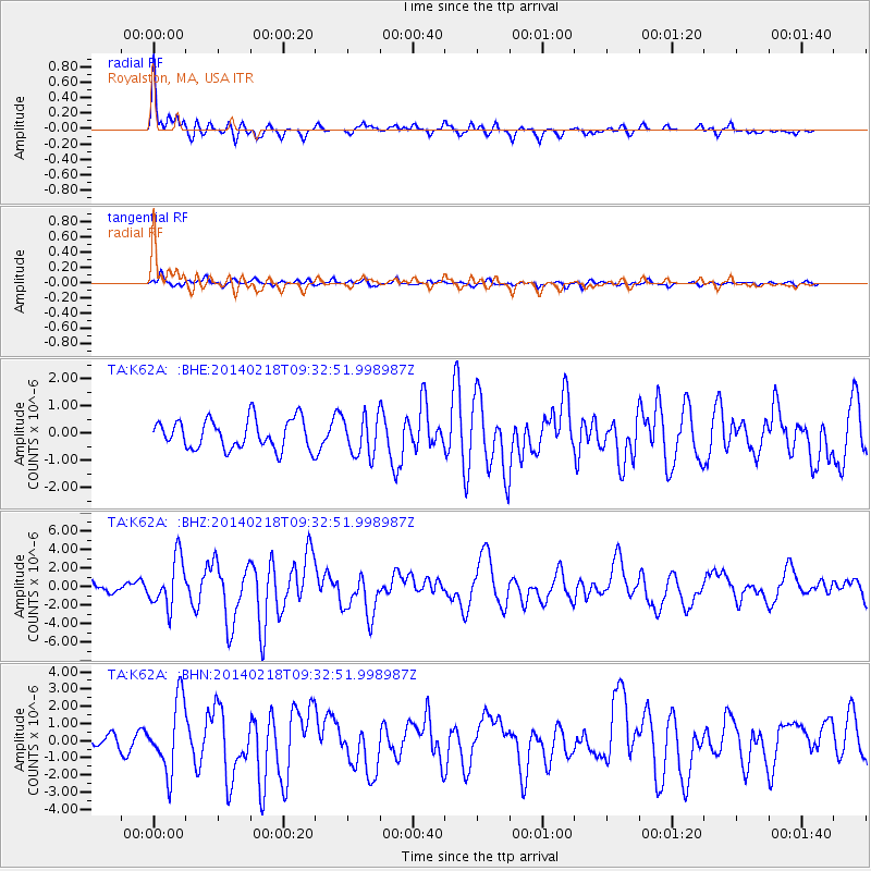
Signal To Noise
| Channel | StoN | STA | LTA |
| TA:K62A: :BHZ:20140218T09:32:51.998987Z | 4.3418403 | 2.6239682E-6 | 6.0434473E-7 |
| TA:K62A: :BHN:20140218T09:32:51.998987Z | 5.574903 | 2.043012E-6 | 3.6646594E-7 |
| TA:K62A: :BHE:20140218T09:32:51.998987Z | 1.3410821 | 7.2254034E-7 | 5.3877415E-7 |
| Arrivals |
| Ps | 3.7 SECOND |
| PpPs | 9.1 SECOND |
| PsPs/PpSs | 13 SECOND |


