You are here: Home > Network List > TA - USArray Transportable Network (new EarthScope stations) Stations List
> Station L50A Kingsville, ON, CAN > Earthquake Result Viewer
L50A Kingsville, ON, CAN - Earthquake Result Viewer

| Earthquake location: |
North Atlantic Ocean |
| Earthquake latitude/longitude: |
14.7/-58.9 |
| Earthquake time(UTC): |
2014/02/18 (049) 09:27:13 GMT |
| Earthquake Depth: |
17 km |
| Earthquake Magnitude: |
6.5 MWW, 6.3 MWB, 6.5 MWC, 6.6 MWC, 6.7 MI |
| Earthquake Catalog/Contributor: |
NEIC PDE/NEIC COMCAT |
|
| Network: |
TA USArray Transportable Network (new EarthScope stations) |
| Station: |
L50A Kingsville, ON, CAN |
| Lat/Lon: |
42.04 N/82.81 W |
| Elevation: |
187 m |
|
| Distance: |
34.2 deg |
| Az: |
327.57 deg |
| Baz: |
135.826 deg |
| Ray Param: |
0.07783597 |
| Estimated Moho Depth: |
53.0 km |
| Estimated Crust Vp/Vs: |
2.06 |
| Assumed Crust Vp: |
6.483 km/s |
| Estimated Crust Vs: |
3.151 km/s |
| Estimated Crust Poisson's Ratio: |
0.35 |
|
| Radial Match: |
91.53857 % |
| Radial Bump: |
327 |
| Transverse Match: |
59.243385 % |
| Transverse Bump: |
400 |
| SOD ConfigId: |
626651 |
| Insert Time: |
2014-04-20 19:16:56.572 +0000 |
| GWidth: |
2.5 |
| Max Bumps: |
400 |
| Tol: |
0.001 |
|
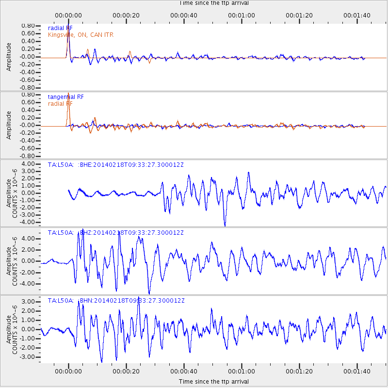
Signal To Noise
| Channel | StoN | STA | LTA |
| TA:L50A: :BHZ:20140218T09:33:27.300012Z | 6.9947357 | 2.266021E-6 | 3.239609E-7 |
| TA:L50A: :BHN:20140218T09:33:27.300012Z | 4.15853 | 1.2504187E-6 | 3.0068765E-7 |
| TA:L50A: :BHE:20140218T09:33:27.300012Z | 3.394079 | 9.783566E-7 | 2.8825394E-7 |
| Arrivals |
| Ps | 9.2 SECOND |
| PpPs | 23 SECOND |
| PsPs/PpSs | 33 SECOND |


