You are here: Home > Network List > TA - USArray Transportable Network (new EarthScope stations) Stations List
> Station L56A Greenwood, NY, USA > Earthquake Result Viewer
L56A Greenwood, NY, USA - Earthquake Result Viewer
| Earthquake location: |
North Atlantic Ocean |
| Earthquake latitude/longitude: |
14.7/-58.9 |
| Earthquake time(UTC): |
2014/02/18 (049) 09:27:13 GMT |
| Earthquake Depth: |
17 km |
| Earthquake Magnitude: |
6.5 MWW, 6.3 MWB, 6.5 MWC, 6.6 MWC, 6.7 MI |
| Earthquake Catalog/Contributor: |
NEIC PDE/NEIC COMCAT |
|
| Network: |
TA USArray Transportable Network (new EarthScope stations) |
| Station: |
L56A Greenwood, NY, USA |
| Lat/Lon: |
42.14 N/77.56 W |
| Elevation: |
688 m |
|
| Distance: |
31.8 deg |
| Az: |
333.173 deg |
| Baz: |
144.035 deg |
| Ray Param: |
0.07892345 |
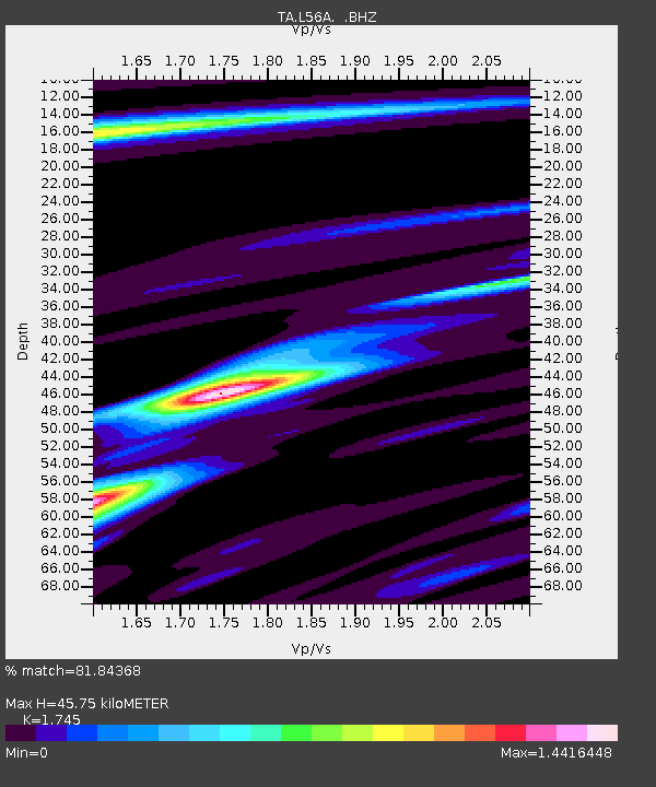
| Estimated Moho Depth: |
45.75 km |
| Estimated Crust Vp/Vs: |
1.75 |
| Assumed Crust Vp: |
6.476 km/s |
| Estimated Crust Vs: |
3.711 km/s |
| Estimated Crust Poisson's Ratio: |
0.26 |
|
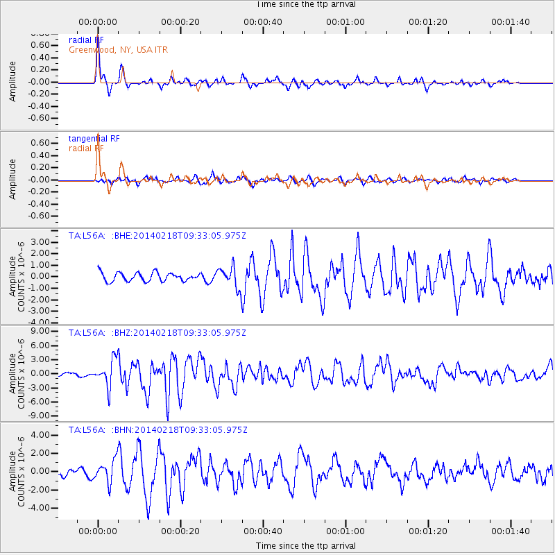
| Radial Match: |
81.84368 % |
| Radial Bump: |
326 |
| Transverse Match: |
73.432625 % |
| Transverse Bump: |
400 |
| SOD ConfigId: |
626651 |
| Insert Time: |
2014-04-20 19:17:07.880 +0000 |
| GWidth: |
2.5 |
| Max Bumps: |
400 |
| Tol: |
0.001 |
|
Signal To Noise
| Channel | StoN | STA | LTA |
| TA:L56A: :BHZ:20140218T09:33:05.975Z | 6.3866553 | 2.9862408E-6 | 4.675751E-7 |
| TA:L56A: :BHN:20140218T09:33:05.975Z | 3.4034653 | 1.2632945E-6 | 3.711789E-7 |
| TA:L56A: :BHE:20140218T09:33:05.975Z | 2.6091888 | 9.62701E-7 | 3.6896563E-7 |
| Arrivals |
| Ps | 5.7 SECOND |
| PpPs | 18 SECOND |
| PsPs/PpSs | 24 SECOND |


