You are here: Home > Network List > TA - USArray Transportable Network (new EarthScope stations) Stations List
> Station M52A Chesterland, OH, USA > Earthquake Result Viewer
M52A Chesterland, OH, USA - Earthquake Result Viewer
| Earthquake location: |
North Atlantic Ocean |
| Earthquake latitude/longitude: |
14.7/-58.9 |
| Earthquake time(UTC): |
2014/02/18 (049) 09:27:13 GMT |
| Earthquake Depth: |
17 km |
| Earthquake Magnitude: |
6.5 MWW, 6.3 MWB, 6.5 MWC, 6.6 MWC, 6.7 MI |
| Earthquake Catalog/Contributor: |
NEIC PDE/NEIC COMCAT |
|
| Network: |
TA USArray Transportable Network (new EarthScope stations) |
| Station: |
M52A Chesterland, OH, USA |
| Lat/Lon: |
41.54 N/81.36 W |
| Elevation: |
382 m |
|
| Distance: |
33.1 deg |
| Az: |
328.373 deg |
| Baz: |
137.459 deg |
| Ray Param: |
0.078347534 |
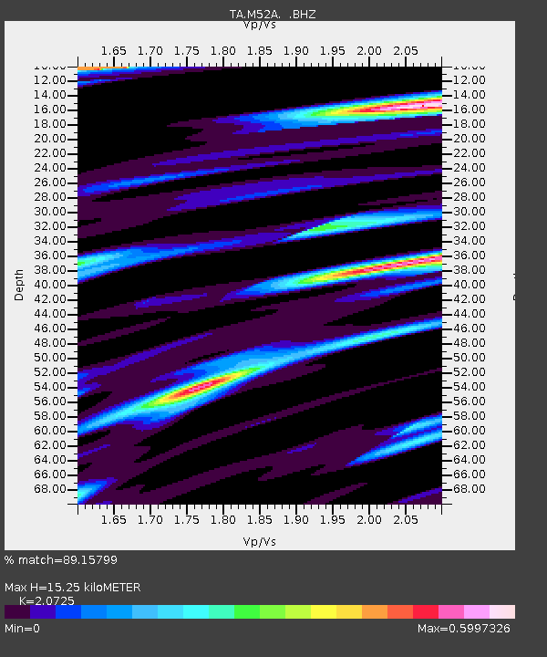
| Estimated Moho Depth: |
15.25 km |
| Estimated Crust Vp/Vs: |
2.07 |
| Assumed Crust Vp: |
6.483 km/s |
| Estimated Crust Vs: |
3.128 km/s |
| Estimated Crust Poisson's Ratio: |
0.35 |
|
| Radial Match: |
89.15799 % |
| Radial Bump: |
307 |
| Transverse Match: |
62.631428 % |
| Transverse Bump: |
400 |
| SOD ConfigId: |
626651 |
| Insert Time: |
2014-04-20 19:17:48.181 +0000 |
| GWidth: |
2.5 |
| Max Bumps: |
400 |
| Tol: |
0.001 |
|

Signal To Noise
| Channel | StoN | STA | LTA |
| TA:M52A: :BHZ:20140218T09:33:17.649988Z | 6.977348 | 2.1741093E-6 | 3.1159536E-7 |
| TA:M52A: :BHN:20140218T09:33:17.649988Z | 3.5767615 | 1.0784012E-6 | 3.0150213E-7 |
| TA:M52A: :BHE:20140218T09:33:17.649988Z | 2.129566 | 9.145223E-7 | 4.294407E-7 |
| Arrivals |
| Ps | 2.7 SECOND |
| PpPs | 6.8 SECOND |
| PsPs/PpSs | 9.5 SECOND |


