You are here: Home > Network List > TA - USArray Transportable Network (new EarthScope stations) Stations List
> Station N53A Lisbon, OH, USA > Earthquake Result Viewer
N53A Lisbon, OH, USA - Earthquake Result Viewer
| Earthquake location: |
North Atlantic Ocean |
| Earthquake latitude/longitude: |
14.7/-58.9 |
| Earthquake time(UTC): |
2014/02/18 (049) 09:27:13 GMT |
| Earthquake Depth: |
17 km |
| Earthquake Magnitude: |
6.5 MWW, 6.3 MWB, 6.5 MWC, 6.6 MWC, 6.7 MI |
| Earthquake Catalog/Contributor: |
NEIC PDE/NEIC COMCAT |
|
| Network: |
TA USArray Transportable Network (new EarthScope stations) |
| Station: |
N53A Lisbon, OH, USA |
| Lat/Lon: |
40.81 N/80.84 W |
| Elevation: |
360 m |
|
| Distance: |
32.3 deg |
| Az: |
327.99 deg |
| Baz: |
137.477 deg |
| Ray Param: |
0.07869799 |
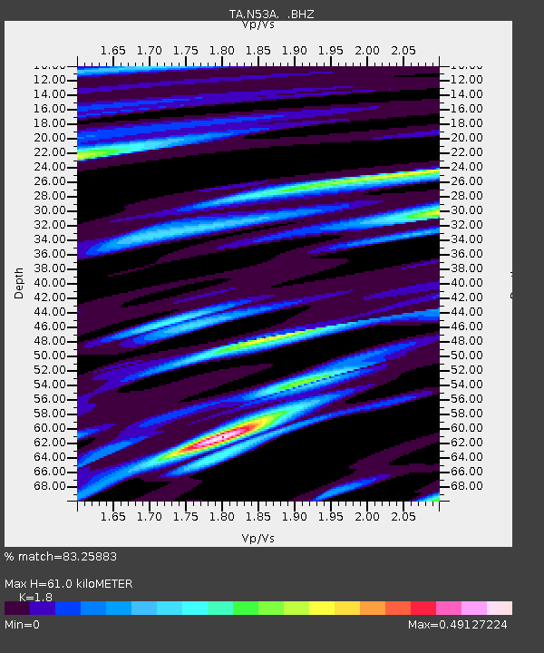
| Estimated Moho Depth: |
61.0 km |
| Estimated Crust Vp/Vs: |
1.80 |
| Assumed Crust Vp: |
6.483 km/s |
| Estimated Crust Vs: |
3.601 km/s |
| Estimated Crust Poisson's Ratio: |
0.28 |
|
| Radial Match: |
83.25883 % |
| Radial Bump: |
291 |
| Transverse Match: |
67.20335 % |
| Transverse Bump: |
400 |
| SOD ConfigId: |
626651 |
| Insert Time: |
2014-04-20 19:18:35.784 +0000 |
| GWidth: |
2.5 |
| Max Bumps: |
400 |
| Tol: |
0.001 |
|

Signal To Noise
| Channel | StoN | STA | LTA |
| TA:N53A: :BHZ:20140218T09:33:10.623987Z | 7.613314 | 2.5814625E-6 | 3.3907213E-7 |
| TA:N53A: :BHN:20140218T09:33:10.623987Z | 3.5251606 | 1.1577268E-6 | 3.284182E-7 |
| TA:N53A: :BHE:20140218T09:33:10.623987Z | 2.2332745 | 9.137672E-7 | 4.091603E-7 |
| Arrivals |
| Ps | 8.1 SECOND |
| PpPs | 24 SECOND |
| PsPs/PpSs | 32 SECOND |


