You are here: Home > Network List > TA - USArray Transportable Network (new EarthScope stations) Stations List
> Station O51A Pataskala, OH, USA > Earthquake Result Viewer
O51A Pataskala, OH, USA - Earthquake Result Viewer

| Earthquake location: |
North Atlantic Ocean |
| Earthquake latitude/longitude: |
14.7/-58.9 |
| Earthquake time(UTC): |
2014/02/18 (049) 09:27:13 GMT |
| Earthquake Depth: |
17 km |
| Earthquake Magnitude: |
6.5 MWW, 6.3 MWB, 6.5 MWC, 6.6 MWC, 6.7 MI |
| Earthquake Catalog/Contributor: |
NEIC PDE/NEIC COMCAT |
|
| Network: |
TA USArray Transportable Network (new EarthScope stations) |
| Station: |
O51A Pataskala, OH, USA |
| Lat/Lon: |
40.15 N/82.61 W |
| Elevation: |
380 m |
|
| Distance: |
32.8 deg |
| Az: |
325.338 deg |
| Baz: |
134.098 deg |
| Ray Param: |
0.078498855 |
| Estimated Moho Depth: |
32.5 km |
| Estimated Crust Vp/Vs: |
2.10 |
| Assumed Crust Vp: |
6.498 km/s |
| Estimated Crust Vs: |
3.098 km/s |
| Estimated Crust Poisson's Ratio: |
0.35 |
|
| Radial Match: |
80.45132 % |
| Radial Bump: |
400 |
| Transverse Match: |
55.99443 % |
| Transverse Bump: |
400 |
| SOD ConfigId: |
626651 |
| Insert Time: |
2014-04-20 19:19:10.566 +0000 |
| GWidth: |
2.5 |
| Max Bumps: |
400 |
| Tol: |
0.001 |
|
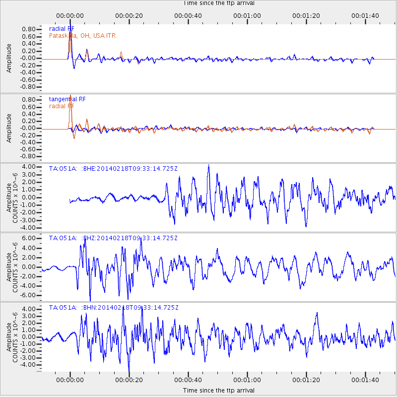
Signal To Noise
| Channel | StoN | STA | LTA |
| TA:O51A: :BHZ:20140218T09:33:14.725Z | 5.6344275 | 2.1639523E-6 | 3.8405892E-7 |
| TA:O51A: :BHN:20140218T09:33:14.725Z | 3.703441 | 1.1756641E-6 | 3.1745182E-7 |
| TA:O51A: :BHE:20140218T09:33:14.725Z | 3.759909 | 1.059031E-6 | 2.81664E-7 |
| Arrivals |
| Ps | 5.9 SECOND |
| PpPs | 14 SECOND |
| PsPs/PpSs | 20 SECOND |


