You are here: Home > Network List > TA - USArray Transportable Network (new EarthScope stations) Stations List
> Station O55A Ligonier, PA, USA > Earthquake Result Viewer
O55A Ligonier, PA, USA - Earthquake Result Viewer
| Earthquake location: |
North Atlantic Ocean |
| Earthquake latitude/longitude: |
14.7/-58.9 |
| Earthquake time(UTC): |
2014/02/18 (049) 09:27:13 GMT |
| Earthquake Depth: |
17 km |
| Earthquake Magnitude: |
6.5 MWW, 6.3 MWB, 6.5 MWC, 6.6 MWC, 6.7 MI |
| Earthquake Catalog/Contributor: |
NEIC PDE/NEIC COMCAT |
|
| Network: |
TA USArray Transportable Network (new EarthScope stations) |
| Station: |
O55A Ligonier, PA, USA |
| Lat/Lon: |
40.21 N/79.30 W |
| Elevation: |
469 m |
|
| Distance: |
31.1 deg |
| Az: |
328.897 deg |
| Baz: |
139.241 deg |
| Ray Param: |
0.079156734 |
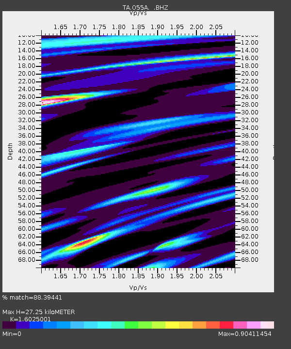
| Estimated Moho Depth: |
27.25 km |
| Estimated Crust Vp/Vs: |
1.60 |
| Assumed Crust Vp: |
6.121 km/s |
| Estimated Crust Vs: |
3.819 km/s |
| Estimated Crust Poisson's Ratio: |
0.18 |
|
| Radial Match: |
88.39441 % |
| Radial Bump: |
400 |
| Transverse Match: |
72.17054 % |
| Transverse Bump: |
400 |
| SOD ConfigId: |
626651 |
| Insert Time: |
2014-04-20 19:19:20.198 +0000 |
| GWidth: |
2.5 |
| Max Bumps: |
400 |
| Tol: |
0.001 |
|
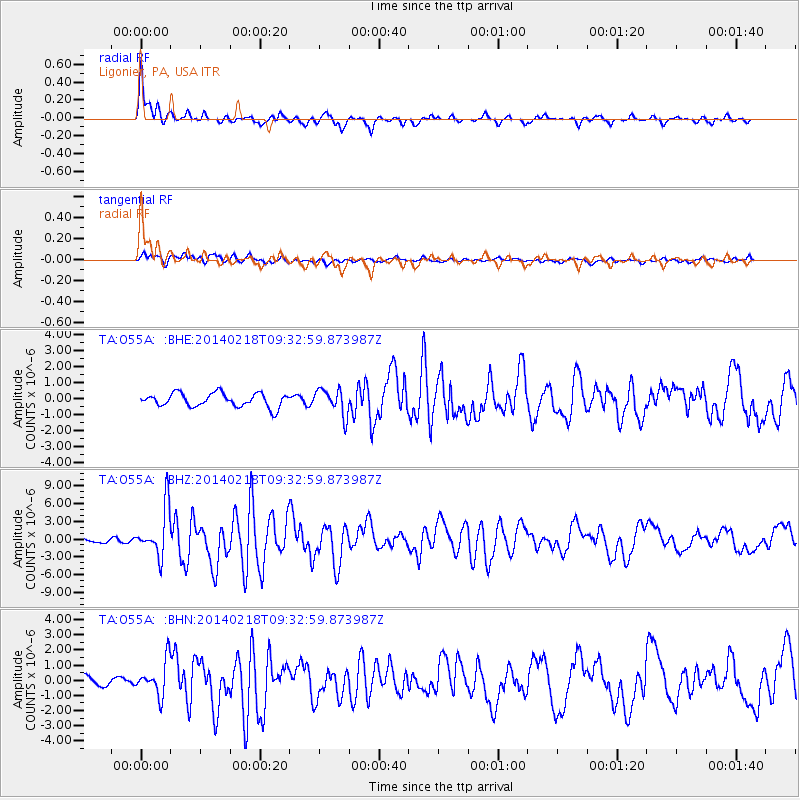
Signal To Noise
| Channel | StoN | STA | LTA |
| TA:O55A: :BHZ:20140218T09:32:59.873987Z | 6.81449 | 4.069182E-6 | 5.9713676E-7 |
| TA:O55A: :BHN:20140218T09:32:59.873987Z | 2.8587224 | 1.139536E-6 | 3.9861723E-7 |
| TA:O55A: :BHE:20140218T09:32:59.873987Z | 1.9338452 | 8.231161E-7 | 4.2563704E-7 |
| Arrivals |
| Ps | 2.9 SECOND |
| PpPs | 11 SECOND |
| PsPs/PpSs | 14 SECOND |


