You are here: Home > Network List > TA - USArray Transportable Network (new EarthScope stations) Stations List
> Station P53A Whipple, OH, USA > Earthquake Result Viewer
P53A Whipple, OH, USA - Earthquake Result Viewer
| Earthquake location: |
North Atlantic Ocean |
| Earthquake latitude/longitude: |
14.7/-58.9 |
| Earthquake time(UTC): |
2014/02/18 (049) 09:27:13 GMT |
| Earthquake Depth: |
17 km |
| Earthquake Magnitude: |
6.5 MWW, 6.3 MWB, 6.5 MWC, 6.6 MWC, 6.7 MI |
| Earthquake Catalog/Contributor: |
NEIC PDE/NEIC COMCAT |
|
| Network: |
TA USArray Transportable Network (new EarthScope stations) |
| Station: |
P53A Whipple, OH, USA |
| Lat/Lon: |
39.49 N/81.39 W |
| Elevation: |
270 m |
|
| Distance: |
31.6 deg |
| Az: |
325.692 deg |
| Baz: |
135.173 deg |
| Ray Param: |
0.07897918 |
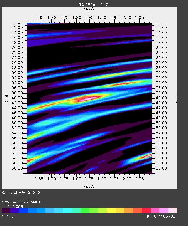
| Estimated Moho Depth: |
62.5 km |
| Estimated Crust Vp/Vs: |
2.10 |
| Assumed Crust Vp: |
6.207 km/s |
| Estimated Crust Vs: |
2.963 km/s |
| Estimated Crust Poisson's Ratio: |
0.35 |
|
| Radial Match: |
90.54348 % |
| Radial Bump: |
400 |
| Transverse Match: |
77.64329 % |
| Transverse Bump: |
400 |
| SOD ConfigId: |
626651 |
| Insert Time: |
2014-04-20 19:19:44.701 +0000 |
| GWidth: |
2.5 |
| Max Bumps: |
400 |
| Tol: |
0.001 |
|

Signal To Noise
| Channel | StoN | STA | LTA |
| TA:P53A: :BHZ:20140218T09:33:04.825006Z | 3.585719 | 2.1763612E-6 | 6.069525E-7 |
| TA:P53A: :BHN:20140218T09:33:04.825006Z | 2.4988604 | 8.4919117E-7 | 3.398314E-7 |
| TA:P53A: :BHE:20140218T09:33:04.825006Z | 3.457624 | 1.1088033E-6 | 3.2068363E-7 |
| Arrivals |
| Ps | 12 SECOND |
| PpPs | 29 SECOND |
| PsPs/PpSs | 41 SECOND |


