You are here: Home > Network List > TA - USArray Transportable Network (new EarthScope stations) Stations List
> Station S49A Springfield, KY, USA > Earthquake Result Viewer
S49A Springfield, KY, USA - Earthquake Result Viewer
| Earthquake location: |
North Atlantic Ocean |
| Earthquake latitude/longitude: |
14.7/-58.9 |
| Earthquake time(UTC): |
2014/02/18 (049) 09:27:13 GMT |
| Earthquake Depth: |
17 km |
| Earthquake Magnitude: |
6.5 MWW, 6.3 MWB, 6.5 MWC, 6.6 MWC, 6.7 MI |
| Earthquake Catalog/Contributor: |
NEIC PDE/NEIC COMCAT |
|
| Network: |
TA USArray Transportable Network (new EarthScope stations) |
| Station: |
S49A Springfield, KY, USA |
| Lat/Lon: |
37.78 N/85.29 W |
| Elevation: |
230 m |
|
| Distance: |
32.8 deg |
| Az: |
319.517 deg |
| Baz: |
127.523 deg |
| Ray Param: |
0.078481294 |
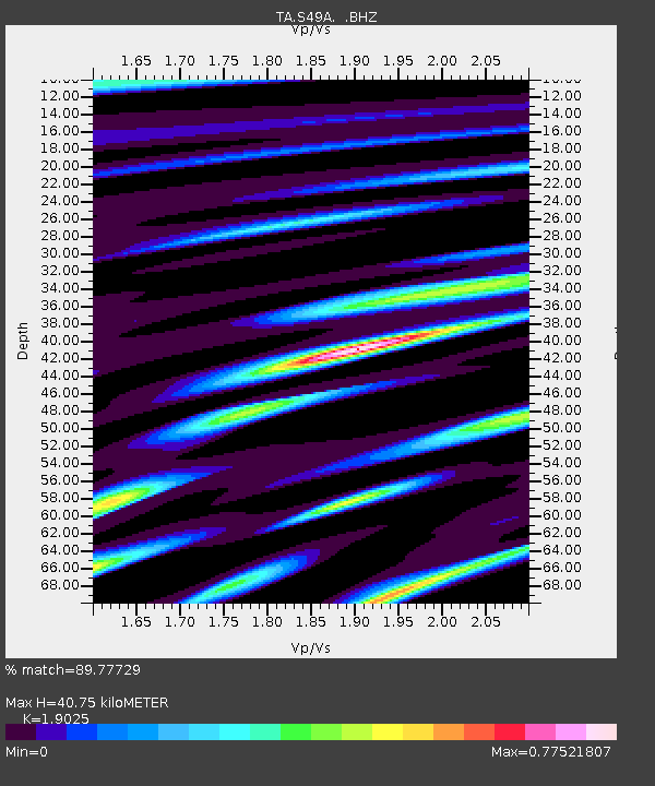
| Estimated Moho Depth: |
40.75 km |
| Estimated Crust Vp/Vs: |
1.90 |
| Assumed Crust Vp: |
6.476 km/s |
| Estimated Crust Vs: |
3.404 km/s |
| Estimated Crust Poisson's Ratio: |
0.31 |
|
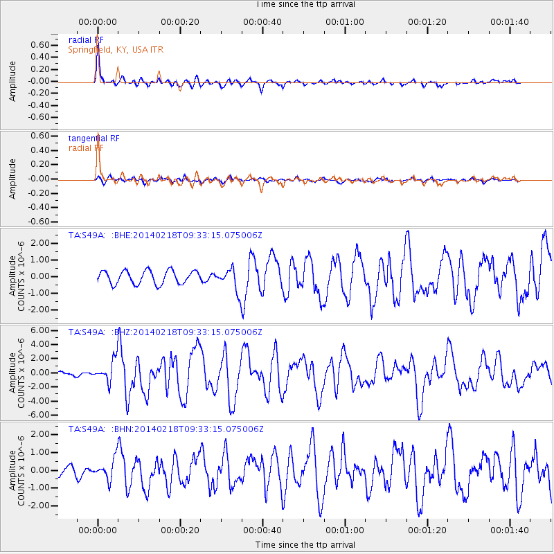
| Radial Match: |
89.77729 % |
| Radial Bump: |
367 |
| Transverse Match: |
72.26175 % |
| Transverse Bump: |
400 |
| SOD ConfigId: |
626651 |
| Insert Time: |
2014-04-20 19:20:50.121 +0000 |
| GWidth: |
2.5 |
| Max Bumps: |
400 |
| Tol: |
0.001 |
|
Signal To Noise
| Channel | StoN | STA | LTA |
| TA:S49A: :BHZ:20140218T09:33:15.075006Z | 5.9929824 | 1.6125415E-6 | 2.6907162E-7 |
| TA:S49A: :BHN:20140218T09:33:15.075006Z | 1.8275051 | 6.246892E-7 | 3.4182628E-7 |
| TA:S49A: :BHE:20140218T09:33:15.075006Z | 1.8103176 | 7.204707E-7 | 3.9798027E-7 |
| Arrivals |
| Ps | 6.1 SECOND |
| PpPs | 17 SECOND |
| PsPs/PpSs | 23 SECOND |


