You are here: Home > Network List > TA - USArray Transportable Network (new EarthScope stations) Stations List
> Station S52A Salyersville, KY, USA > Earthquake Result Viewer
S52A Salyersville, KY, USA - Earthquake Result Viewer

| Earthquake location: |
North Atlantic Ocean |
| Earthquake latitude/longitude: |
14.7/-58.9 |
| Earthquake time(UTC): |
2014/02/18 (049) 09:27:13 GMT |
| Earthquake Depth: |
17 km |
| Earthquake Magnitude: |
6.5 MWW, 6.3 MWB, 6.5 MWC, 6.6 MWC, 6.7 MI |
| Earthquake Catalog/Contributor: |
NEIC PDE/NEIC COMCAT |
|
| Network: |
TA USArray Transportable Network (new EarthScope stations) |
| Station: |
S52A Salyersville, KY, USA |
| Lat/Lon: |
37.68 N/83.08 W |
| Elevation: |
367 m |
|
| Distance: |
31.4 deg |
| Az: |
321.437 deg |
| Baz: |
130.496 deg |
| Ray Param: |
0.07907633 |
| Estimated Moho Depth: |
15.5 km |
| Estimated Crust Vp/Vs: |
1.83 |
| Assumed Crust Vp: |
6.476 km/s |
| Estimated Crust Vs: |
3.534 km/s |
| Estimated Crust Poisson's Ratio: |
0.29 |
|
| Radial Match: |
82.65108 % |
| Radial Bump: |
400 |
| Transverse Match: |
69.97296 % |
| Transverse Bump: |
400 |
| SOD ConfigId: |
626651 |
| Insert Time: |
2014-04-20 19:21:00.149 +0000 |
| GWidth: |
2.5 |
| Max Bumps: |
400 |
| Tol: |
0.001 |
|
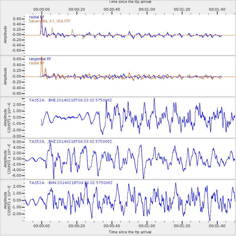
Signal To Noise
| Channel | StoN | STA | LTA |
| TA:S52A: :BHZ:20140218T09:33:02.575006Z | 2.5359392 | 2.1288865E-6 | 8.3948646E-7 |
| TA:S52A: :BHN:20140218T09:33:02.575006Z | 1.7522545 | 7.040432E-7 | 4.017928E-7 |
| TA:S52A: :BHE:20140218T09:33:02.575006Z | 3.1011064 | 1.2213433E-6 | 3.9384113E-7 |
| Arrivals |
| Ps | 2.2 SECOND |
| PpPs | 6.3 SECOND |
| PsPs/PpSs | 8.4 SECOND |


