You are here: Home > Network List > TA - USArray Transportable Network (new EarthScope stations) Stations List
> Station S54A Dingess, Beckley, WV, USA > Earthquake Result Viewer
S54A Dingess, Beckley, WV, USA - Earthquake Result Viewer
| Earthquake location: |
North Atlantic Ocean |
| Earthquake latitude/longitude: |
14.7/-58.9 |
| Earthquake time(UTC): |
2014/02/18 (049) 09:27:13 GMT |
| Earthquake Depth: |
17 km |
| Earthquake Magnitude: |
6.5 MWW, 6.3 MWB, 6.5 MWC, 6.6 MWC, 6.7 MI |
| Earthquake Catalog/Contributor: |
NEIC PDE/NEIC COMCAT |
|
| Network: |
TA USArray Transportable Network (new EarthScope stations) |
| Station: |
S54A Dingess, Beckley, WV, USA |
| Lat/Lon: |
37.80 N/81.31 W |
| Elevation: |
636 m |
|
| Distance: |
30.4 deg |
| Az: |
323.433 deg |
| Baz: |
133.286 deg |
| Ray Param: |
0.07932917 |
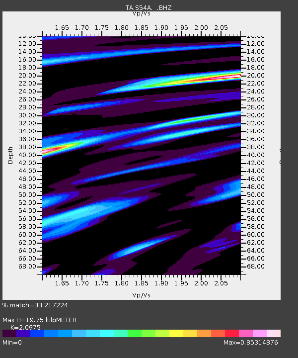
| Estimated Moho Depth: |
19.75 km |
| Estimated Crust Vp/Vs: |
2.10 |
| Assumed Crust Vp: |
6.159 km/s |
| Estimated Crust Vs: |
2.936 km/s |
| Estimated Crust Poisson's Ratio: |
0.35 |
|
| Radial Match: |
83.217224 % |
| Radial Bump: |
377 |
| Transverse Match: |
67.78624 % |
| Transverse Bump: |
400 |
| SOD ConfigId: |
626651 |
| Insert Time: |
2014-04-20 19:21:06.375 +0000 |
| GWidth: |
2.5 |
| Max Bumps: |
400 |
| Tol: |
0.001 |
|

Signal To Noise
| Channel | StoN | STA | LTA |
| TA:S54A: :BHZ:20140218T09:32:54.098993Z | 7.402337 | 2.0192758E-6 | 2.7278895E-7 |
| TA:S54A: :BHN:20140218T09:32:54.098993Z | 2.162411 | 5.3266683E-7 | 2.4633005E-7 |
| TA:S54A: :BHE:20140218T09:32:54.098993Z | 2.8795943 | 7.0724946E-7 | 2.4560734E-7 |
| Arrivals |
| Ps | 3.7 SECOND |
| PpPs | 9.3 SECOND |
| PsPs/PpSs | 13 SECOND |


