You are here: Home > Network List > TA - USArray Transportable Network (new EarthScope stations) Stations List
> Station SFIN Lafayette, IN, USA > Earthquake Result Viewer
SFIN Lafayette, IN, USA - Earthquake Result Viewer
| Earthquake location: |
North Atlantic Ocean |
| Earthquake latitude/longitude: |
14.7/-58.9 |
| Earthquake time(UTC): |
2014/02/18 (049) 09:27:13 GMT |
| Earthquake Depth: |
17 km |
| Earthquake Magnitude: |
6.5 MWW, 6.3 MWB, 6.5 MWC, 6.6 MWC, 6.7 MI |
| Earthquake Catalog/Contributor: |
NEIC PDE/NEIC COMCAT |
|
| Network: |
TA USArray Transportable Network (new EarthScope stations) |
| Station: |
SFIN Lafayette, IN, USA |
| Lat/Lon: |
40.38 N/87.10 W |
| Elevation: |
165 m |
|
| Distance: |
35.5 deg |
| Az: |
321.622 deg |
| Baz: |
128.129 deg |
| Ray Param: |
0.0771689 |
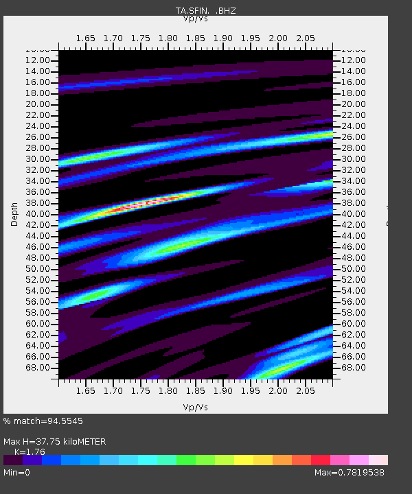
| Estimated Moho Depth: |
37.75 km |
| Estimated Crust Vp/Vs: |
1.76 |
| Assumed Crust Vp: |
6.498 km/s |
| Estimated Crust Vs: |
3.692 km/s |
| Estimated Crust Poisson's Ratio: |
0.26 |
|
| Radial Match: |
94.5545 % |
| Radial Bump: |
265 |
| Transverse Match: |
63.141663 % |
| Transverse Bump: |
400 |
| SOD ConfigId: |
626651 |
| Insert Time: |
2014-04-20 19:21:07.555 +0000 |
| GWidth: |
2.5 |
| Max Bumps: |
400 |
| Tol: |
0.001 |
|

Signal To Noise
| Channel | StoN | STA | LTA |
| TA:SFIN: :BHZ:20140218T09:33:38.450006Z | 5.4965563 | 2.0251293E-6 | 3.68436E-7 |
| TA:SFIN: :BHN:20140218T09:33:38.450006Z | 3.5562484 | 8.8828534E-7 | 2.4978158E-7 |
| TA:SFIN: :BHE:20140218T09:33:38.450006Z | 6.5212793 | 1.3324795E-6 | 2.0432793E-7 |
| Arrivals |
| Ps | 4.8 SECOND |
| PpPs | 15 SECOND |
| PsPs/PpSs | 20 SECOND |


