You are here: Home > Network List > CI - Caltech Regional Seismic Network Stations List
> Station MPM Manuel Prospect Mine, California, USA > Earthquake Result Viewer
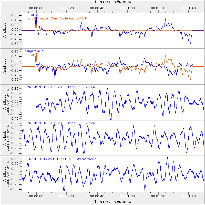
MPM Manuel Prospect Mine, California, USA - Earthquake Result Viewer
*The percent match for this event was below the threshold and hence no stack was calculated.
| Earthquake location: |
Kermadec Islands Region |
| Earthquake latitude/longitude: |
-27.6/-177.1 |
| Earthquake time(UTC): |
2014/12/31 (365) 18:11:10 GMT |
| Earthquake Depth: |
75 km |
| Earthquake Magnitude: |
4.8 mb |
| Earthquake Catalog/Contributor: |
ISC/ISC |
|
| Network: |
CI Caltech Regional Seismic Network |
| Station: |
MPM Manuel Prospect Mine, California, USA |
| Lat/Lon: |
36.06 N/117.49 W |
| Elevation: |
185 m |
|
| Distance: |
84.6 deg |
| Az: |
44.6 deg |
| Baz: |
230.26 deg |
| Ray Param: |
$rayparam |
*The percent match for this event was below the threshold and hence was not used in the summary stack. |
|
| Radial Match: |
57.592415 % |
| Radial Bump: |
400 |
| Transverse Match: |
50.956547 % |
| Transverse Bump: |
400 |
| SOD ConfigId: |
3390531 |
| Insert Time: |
2019-04-15 21:50:00.095 +0000 |
| GWidth: |
2.5 |
| Max Bumps: |
400 |
| Tol: |
0.001 |
|
Signal To Noise
| Channel | StoN | STA | LTA |
| CI:MPM: :HHZ:20141231T18:23:04.927988Z | 1.664786 | 1.609866E-7 | 9.670108E-8 |
| CI:MPM: :HHN:20141231T18:23:04.927988Z | 0.85474974 | 1.3785143E-7 | 1.6127694E-7 |
| CI:MPM: :HHE:20141231T18:23:04.927988Z | 1.4955798 | 1.6843943E-7 | 1.1262483E-7 |
| Arrivals |
| Ps | |
| PpPs | |
| PsPs/PpSs | |


