You are here: Home > Network List > TA - USArray Transportable Network (new EarthScope stations) Stations List
> Station T52A Hallie, KY, USA > Earthquake Result Viewer
T52A Hallie, KY, USA - Earthquake Result Viewer
| Earthquake location: |
North Atlantic Ocean |
| Earthquake latitude/longitude: |
14.7/-58.9 |
| Earthquake time(UTC): |
2014/02/18 (049) 09:27:13 GMT |
| Earthquake Depth: |
17 km |
| Earthquake Magnitude: |
6.5 MWW, 6.3 MWB, 6.5 MWC, 6.6 MWC, 6.7 MI |
| Earthquake Catalog/Contributor: |
NEIC PDE/NEIC COMCAT |
|
| Network: |
TA USArray Transportable Network (new EarthScope stations) |
| Station: |
T52A Hallie, KY, USA |
| Lat/Lon: |
37.11 N/82.99 W |
| Elevation: |
436 m |
|
| Distance: |
31.0 deg |
| Az: |
320.688 deg |
| Baz: |
129.911 deg |
| Ray Param: |
0.07918795 |
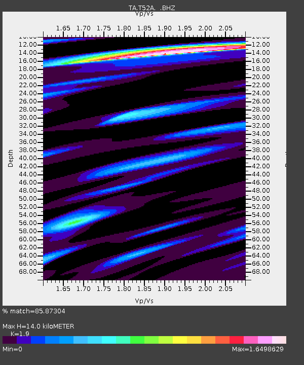
| Estimated Moho Depth: |
14.0 km |
| Estimated Crust Vp/Vs: |
1.90 |
| Assumed Crust Vp: |
6.476 km/s |
| Estimated Crust Vs: |
3.408 km/s |
| Estimated Crust Poisson's Ratio: |
0.31 |
|
| Radial Match: |
85.87304 % |
| Radial Bump: |
400 |
| Transverse Match: |
76.846634 % |
| Transverse Bump: |
400 |
| SOD ConfigId: |
626651 |
| Insert Time: |
2014-04-20 19:21:29.409 +0000 |
| GWidth: |
2.5 |
| Max Bumps: |
400 |
| Tol: |
0.001 |
|
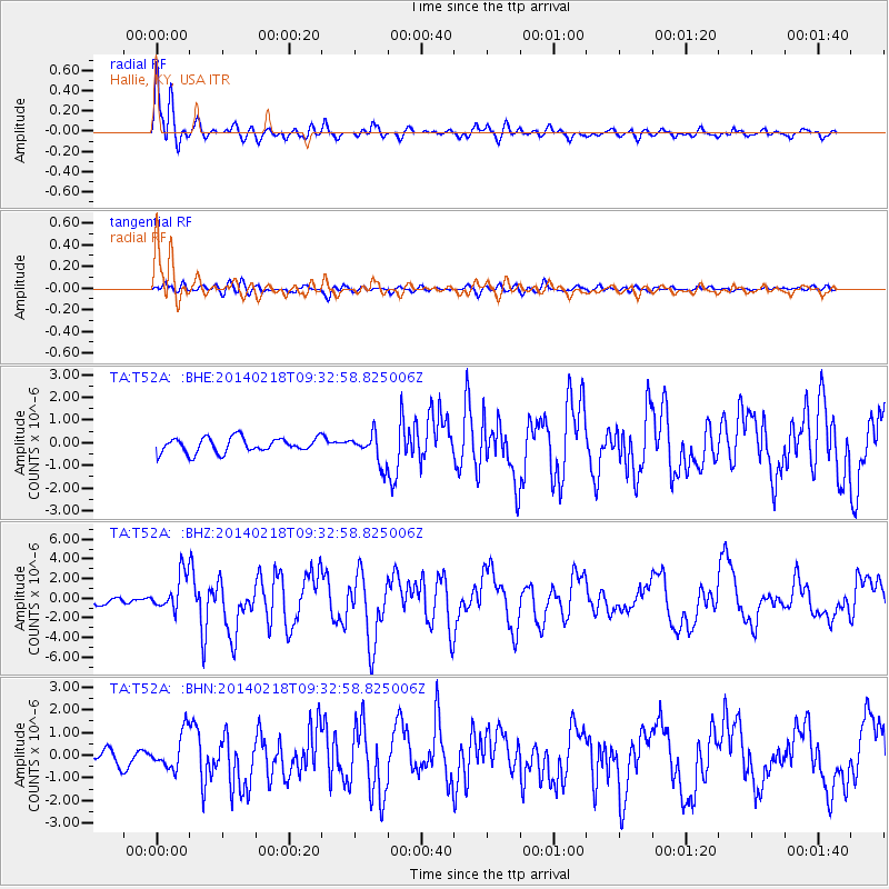
Signal To Noise
| Channel | StoN | STA | LTA |
| TA:T52A: :BHZ:20140218T09:32:58.825006Z | 5.9574533 | 1.8341625E-6 | 3.0787695E-7 |
| TA:T52A: :BHN:20140218T09:32:58.825006Z | 2.3633995 | 7.9315805E-7 | 3.356005E-7 |
| TA:T52A: :BHE:20140218T09:32:58.825006Z | 2.0338538 | 6.6440003E-7 | 3.2667052E-7 |
| Arrivals |
| Ps | 2.1 SECOND |
| PpPs | 5.8 SECOND |
| PsPs/PpSs | 7.9 SECOND |


