You are here: Home > Network List > IU - Global Seismograph Network (GSN - IRIS/USGS) Stations List
> Station RSSD Black Hills, South Dakota, USA > Earthquake Result Viewer
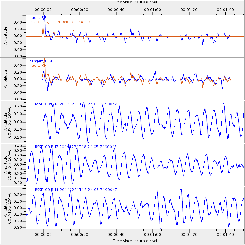
RSSD Black Hills, South Dakota, USA - Earthquake Result Viewer
*The percent match for this event was below the threshold and hence no stack was calculated.
| Earthquake location: |
Kermadec Islands Region |
| Earthquake latitude/longitude: |
-27.6/-177.1 |
| Earthquake time(UTC): |
2014/12/31 (365) 18:11:10 GMT |
| Earthquake Depth: |
75 km |
| Earthquake Magnitude: |
4.8 mb |
| Earthquake Catalog/Contributor: |
ISC/ISC |
|
| Network: |
IU Global Seismograph Network (GSN - IRIS/USGS) |
| Station: |
RSSD Black Hills, South Dakota, USA |
| Lat/Lon: |
44.12 N/104.04 W |
| Elevation: |
2090 m |
|
| Distance: |
97.7 deg |
| Az: |
44.05 deg |
| Baz: |
238.946 deg |
| Ray Param: |
$rayparam |
*The percent match for this event was below the threshold and hence was not used in the summary stack. |
|
| Radial Match: |
73.37219 % |
| Radial Bump: |
400 |
| Transverse Match: |
39.24793 % |
| Transverse Bump: |
400 |
| SOD ConfigId: |
3390531 |
| Insert Time: |
2019-04-15 21:50:51.479 +0000 |
| GWidth: |
2.5 |
| Max Bumps: |
400 |
| Tol: |
0.001 |
|
Signal To Noise
| Channel | StoN | STA | LTA |
| IU:RSSD:00:BHZ:20141231T18:24:05.719004Z | 1.8675432 | 2.852957E-7 | 1.5276524E-7 |
| IU:RSSD:00:BH1:20141231T18:24:05.719004Z | 1.2610148 | 1.9327832E-7 | 1.5327205E-7 |
| IU:RSSD:00:BH2:20141231T18:24:05.719004Z | 1.1132158 | 1.3848575E-7 | 1.2440152E-7 |
| Arrivals |
| Ps | |
| PpPs | |
| PsPs/PpSs | |


