You are here: Home > Network List > TA - USArray Transportable Network (new EarthScope stations) Stations List
> Station O03E Paynes Creek, CA, USA > Earthquake Result Viewer
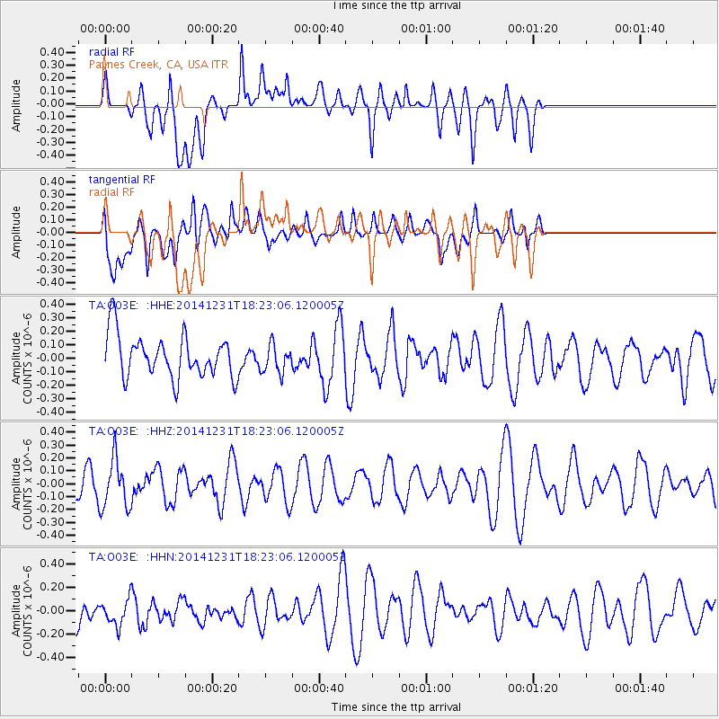
O03E Paynes Creek, CA, USA - Earthquake Result Viewer
*The percent match for this event was below the threshold and hence no stack was calculated.
| Earthquake location: |
Kermadec Islands Region |
| Earthquake latitude/longitude: |
-27.6/-177.1 |
| Earthquake time(UTC): |
2014/12/31 (365) 18:11:10 GMT |
| Earthquake Depth: |
75 km |
| Earthquake Magnitude: |
4.8 mb |
| Earthquake Catalog/Contributor: |
ISC/ISC |
|
| Network: |
TA USArray Transportable Network (new EarthScope stations) |
| Station: |
O03E Paynes Creek, CA, USA |
| Lat/Lon: |
40.29 N/121.80 W |
| Elevation: |
967 m |
|
| Distance: |
84.9 deg |
| Az: |
39.158 deg |
| Baz: |
227.105 deg |
| Ray Param: |
$rayparam |
*The percent match for this event was below the threshold and hence was not used in the summary stack. |
|
| Radial Match: |
68.63535 % |
| Radial Bump: |
400 |
| Transverse Match: |
48.8828 % |
| Transverse Bump: |
400 |
| SOD ConfigId: |
3390531 |
| Insert Time: |
2019-04-15 21:52:07.094 +0000 |
| GWidth: |
2.5 |
| Max Bumps: |
400 |
| Tol: |
0.001 |
|
Signal To Noise
| Channel | StoN | STA | LTA |
| TA:O03E: :HHZ:20141231T18:23:06.120005Z | 1.9817591 | 1.9090739E-7 | 9.633229E-8 |
| TA:O03E: :HHN:20141231T18:23:06.120005Z | 0.907375 | 1.19167744E-7 | 1.3133241E-7 |
| TA:O03E: :HHE:20141231T18:23:06.120005Z | 0.67480004 | 1.05743986E-7 | 1.5670417E-7 |
| Arrivals |
| Ps | |
| PpPs | |
| PsPs/PpSs | |


