You are here: Home > Network List > US - United States National Seismic Network Stations List
> Station BRAL Brewton, Alabama, USA > Earthquake Result Viewer
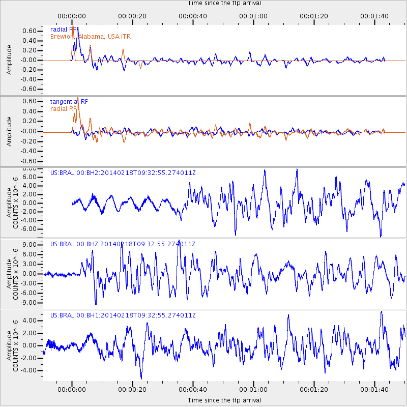
BRAL Brewton, Alabama, USA - Earthquake Result Viewer
*The percent match for this event was below the threshold and hence no stack was calculated.
| Earthquake location: |
North Atlantic Ocean |
| Earthquake latitude/longitude: |
14.7/-58.9 |
| Earthquake time(UTC): |
2014/02/18 (049) 09:27:13 GMT |
| Earthquake Depth: |
17 km |
| Earthquake Magnitude: |
6.5 MWW, 6.3 MWB, 6.5 MWC, 6.6 MWC, 6.7 MI |
| Earthquake Catalog/Contributor: |
NEIC PDE/NEIC COMCAT |
|
| Network: |
US United States National Seismic Network |
| Station: |
BRAL Brewton, Alabama, USA |
| Lat/Lon: |
31.01 N/87.06 W |
| Elevation: |
61 m |
|
| Distance: |
30.5 deg |
| Az: |
307.08 deg |
| Baz: |
115.925 deg |
| Ray Param: |
$rayparam |
*The percent match for this event was below the threshold and hence was not used in the summary stack. |
|
| Radial Match: |
81.40043 % |
| Radial Bump: |
386 |
| Transverse Match: |
62.26486 % |
| Transverse Bump: |
400 |
| SOD ConfigId: |
626651 |
| Insert Time: |
2014-04-20 19:23:11.617 +0000 |
| GWidth: |
2.5 |
| Max Bumps: |
400 |
| Tol: |
0.001 |
|
Signal To Noise
| Channel | StoN | STA | LTA |
| US:BRAL:00:BHZ:20140218T09:32:55.274011Z | 2.1874611 | 1.5071746E-6 | 6.8900636E-7 |
| US:BRAL:00:BH1:20140218T09:32:55.274011Z | 0.609705 | 4.855284E-7 | 7.963333E-7 |
| US:BRAL:00:BH2:20140218T09:32:55.274011Z | 0.9927365 | 1.0269129E-6 | 1.0344264E-6 |
| Arrivals |
| Ps | |
| PpPs | |
| PsPs/PpSs | |


