You are here: Home > Network List > UW - Pacific Northwest Regional Seismic Network Stations List
> Station LEBA Lebam, WA, USA > Earthquake Result Viewer
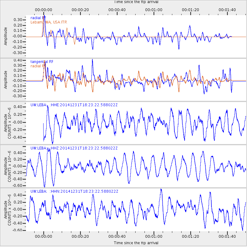
LEBA Lebam, WA, USA - Earthquake Result Viewer
*The percent match for this event was below the threshold and hence no stack was calculated.
| Earthquake location: |
Kermadec Islands Region |
| Earthquake latitude/longitude: |
-27.6/-177.1 |
| Earthquake time(UTC): |
2014/12/31 (365) 18:11:10 GMT |
| Earthquake Depth: |
75 km |
| Earthquake Magnitude: |
4.8 mb |
| Earthquake Catalog/Contributor: |
ISC/ISC |
|
| Network: |
UW Pacific Northwest Regional Seismic Network |
| Station: |
LEBA Lebam, WA, USA |
| Lat/Lon: |
46.55 N/123.56 W |
| Elevation: |
73 m |
|
| Distance: |
88.3 deg |
| Az: |
33.742 deg |
| Baz: |
225.573 deg |
| Ray Param: |
$rayparam |
*The percent match for this event was below the threshold and hence was not used in the summary stack. |
|
| Radial Match: |
33.384815 % |
| Radial Bump: |
400 |
| Transverse Match: |
43.445217 % |
| Transverse Bump: |
400 |
| SOD ConfigId: |
3390531 |
| Insert Time: |
2019-04-15 21:52:42.302 +0000 |
| GWidth: |
2.5 |
| Max Bumps: |
400 |
| Tol: |
0.001 |
|
Signal To Noise
| Channel | StoN | STA | LTA |
| UW:LEBA: :HHZ:20141231T18:23:22.588022Z | 1.8249913 | 4.0106593E-7 | 2.1976318E-7 |
| UW:LEBA: :HHN:20141231T18:23:22.588022Z | 0.74571216 | 1.6482741E-7 | 2.2103357E-7 |
| UW:LEBA: :HHE:20141231T18:23:22.588022Z | 0.68536437 | 1.4242718E-7 | 2.0781235E-7 |
| Arrivals |
| Ps | |
| PpPs | |
| PsPs/PpSs | |


