You are here: Home > Network List > US - United States National Seismic Network Stations List
> Station HDIL Hopedale, Illinois, USA > Earthquake Result Viewer
HDIL Hopedale, Illinois, USA - Earthquake Result Viewer

| Earthquake location: |
North Atlantic Ocean |
| Earthquake latitude/longitude: |
14.7/-58.9 |
| Earthquake time(UTC): |
2014/02/18 (049) 09:27:13 GMT |
| Earthquake Depth: |
17 km |
| Earthquake Magnitude: |
6.5 MWW, 6.3 MWB, 6.5 MWC, 6.6 MWC, 6.7 MI |
| Earthquake Catalog/Contributor: |
NEIC PDE/NEIC COMCAT |
|
| Network: |
US United States National Seismic Network |
| Station: |
HDIL Hopedale, Illinois, USA |
| Lat/Lon: |
40.56 N/89.29 W |
| Elevation: |
219 m |
|
| Distance: |
37.0 deg |
| Az: |
320.162 deg |
| Baz: |
125.53 deg |
| Ray Param: |
0.07638167 |
| Estimated Moho Depth: |
54.5 km |
| Estimated Crust Vp/Vs: |
1.88 |
| Assumed Crust Vp: |
6.498 km/s |
| Estimated Crust Vs: |
3.447 km/s |
| Estimated Crust Poisson's Ratio: |
0.30 |
|
| Radial Match: |
90.40511 % |
| Radial Bump: |
400 |
| Transverse Match: |
64.86399 % |
| Transverse Bump: |
400 |
| SOD ConfigId: |
626651 |
| Insert Time: |
2014-04-20 19:23:51.244 +0000 |
| GWidth: |
2.5 |
| Max Bumps: |
400 |
| Tol: |
0.001 |
|
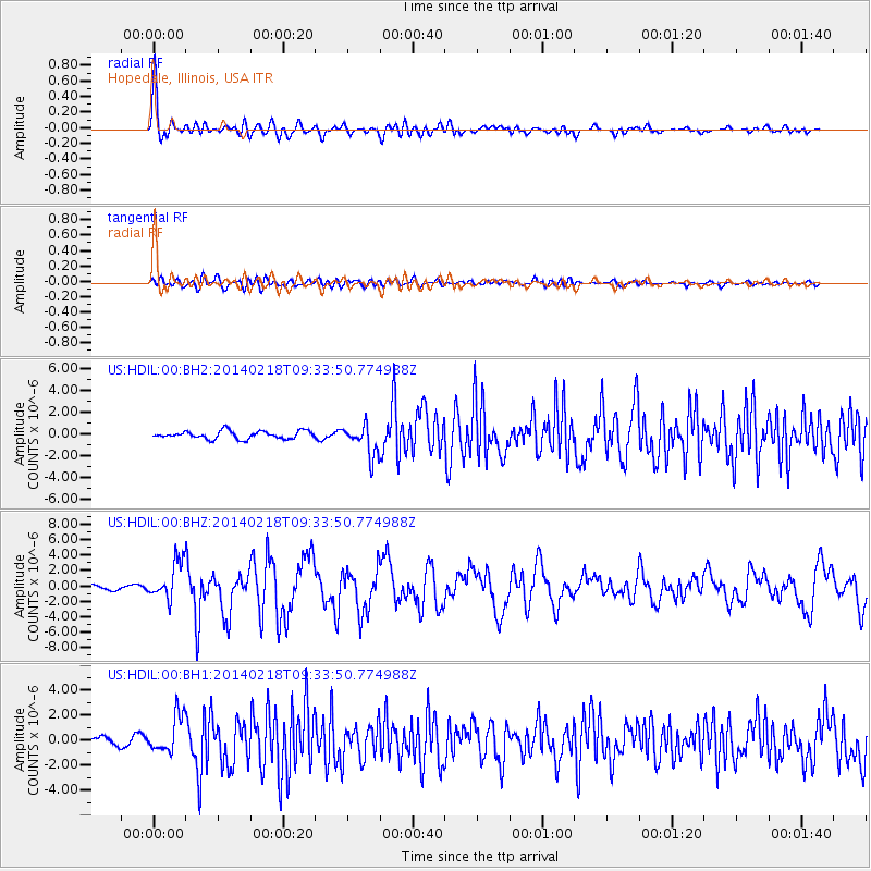
Signal To Noise
| Channel | StoN | STA | LTA |
| US:HDIL:00:BHZ:20140218T09:33:50.774988Z | 5.1009297 | 2.4641095E-6 | 4.8307066E-7 |
| US:HDIL:00:BH1:20140218T09:33:50.774988Z | 2.862195 | 1.4653205E-6 | 5.119569E-7 |
| US:HDIL:00:BH2:20140218T09:33:50.774988Z | 3.9097018 | 1.3967122E-6 | 3.5724264E-7 |
| Arrivals |
| Ps | 8.0 SECOND |
| PpPs | 23 SECOND |
| PsPs/PpSs | 31 SECOND |


