You are here: Home > Network List > US - United States National Seismic Network Stations List
> Station NATX Nacogdoches, Texas, USA > Earthquake Result Viewer
NATX Nacogdoches, Texas, USA - Earthquake Result Viewer
| Earthquake location: |
North Atlantic Ocean |
| Earthquake latitude/longitude: |
14.7/-58.9 |
| Earthquake time(UTC): |
2014/02/18 (049) 09:27:13 GMT |
| Earthquake Depth: |
17 km |
| Earthquake Magnitude: |
6.5 MWW, 6.3 MWB, 6.5 MWC, 6.6 MWC, 6.7 MI |
| Earthquake Catalog/Contributor: |
NEIC PDE/NEIC COMCAT |
|
| Network: |
US United States National Seismic Network |
| Station: |
NATX Nacogdoches, Texas, USA |
| Lat/Lon: |
31.76 N/94.66 W |
| Elevation: |
156 m |
|
| Distance: |
36.8 deg |
| Az: |
303.814 deg |
| Baz: |
109.256 deg |
| Ray Param: |
0.07647827 |
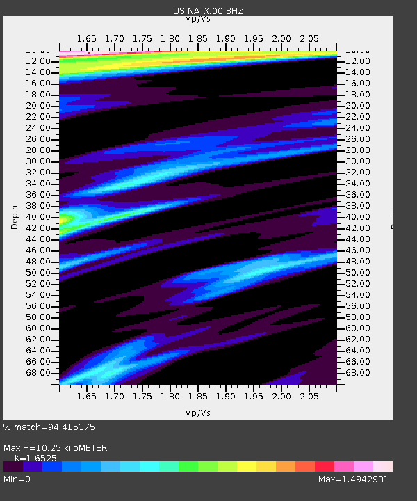
| Estimated Moho Depth: |
10.25 km |
| Estimated Crust Vp/Vs: |
1.65 |
| Assumed Crust Vp: |
5.738 km/s |
| Estimated Crust Vs: |
3.473 km/s |
| Estimated Crust Poisson's Ratio: |
0.21 |
|
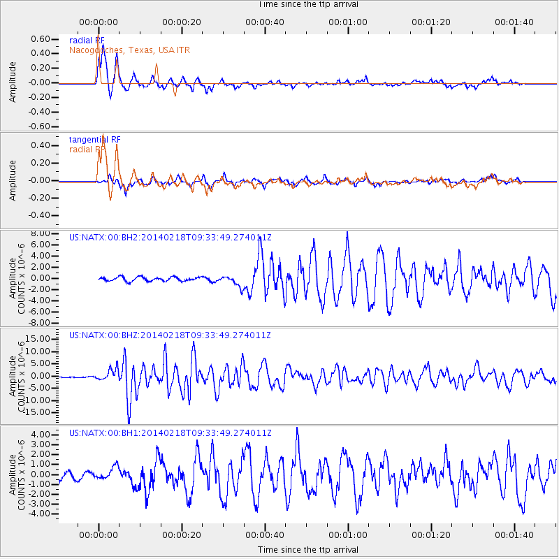
| Radial Match: |
94.415375 % |
| Radial Bump: |
316 |
| Transverse Match: |
76.07444 % |
| Transverse Bump: |
400 |
| SOD ConfigId: |
626651 |
| Insert Time: |
2014-04-20 19:24:35.183 +0000 |
| GWidth: |
2.5 |
| Max Bumps: |
400 |
| Tol: |
0.001 |
|
Signal To Noise
| Channel | StoN | STA | LTA |
| US:NATX:00:BHZ:20140218T09:33:49.274011Z | 6.9925585 | 2.5130767E-6 | 3.59393E-7 |
| US:NATX:00:BH1:20140218T09:33:49.274011Z | 1.3949702 | 6.6586557E-7 | 4.773332E-7 |
| US:NATX:00:BH2:20140218T09:33:49.274011Z | 2.8750482 | 1.0253768E-6 | 3.566468E-7 |
| Arrivals |
| Ps | 1.2 SECOND |
| PpPs | 4.5 SECOND |
| PsPs/PpSs | 5.7 SECOND |


