You are here: Home > Network List > TA - USArray Transportable Network (new EarthScope stations) Stations List
> Station G59A Clarenceville, QC, USA > Earthquake Result Viewer
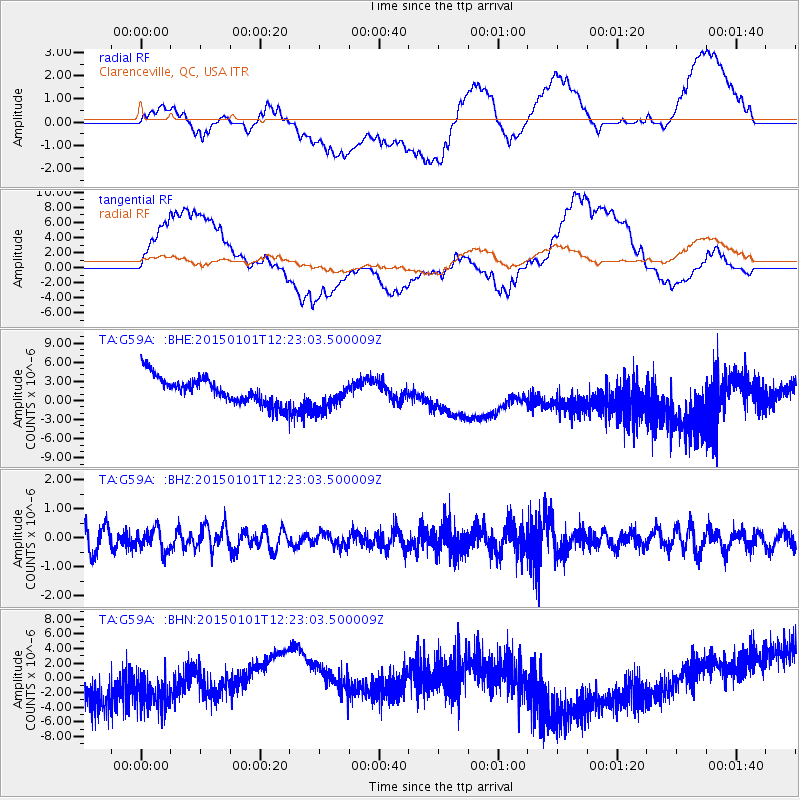
G59A Clarenceville, QC, USA - Earthquake Result Viewer
*The percent match for this event was below the threshold and hence no stack was calculated.
| Earthquake location: |
Off Coast Of Northern California |
| Earthquake latitude/longitude: |
40.4/-125.6 |
| Earthquake time(UTC): |
2015/01/01 (001) 12:16:14 GMT |
| Earthquake Depth: |
10 km |
| Earthquake Magnitude: |
5.4 MW, 4.5 MS, 5.2 mb |
| Earthquake Catalog/Contributor: |
ISC/ISC |
|
| Network: |
TA USArray Transportable Network (new EarthScope stations) |
| Station: |
G59A Clarenceville, QC, USA |
| Lat/Lon: |
45.08 N/73.18 W |
| Elevation: |
36 m |
|
| Distance: |
38.2 deg |
| Az: |
65.205 deg |
| Baz: |
282.043 deg |
| Ray Param: |
$rayparam |
*The percent match for this event was below the threshold and hence was not used in the summary stack. |
|
| Radial Match: |
32.51282 % |
| Radial Bump: |
400 |
| Transverse Match: |
43.420467 % |
| Transverse Bump: |
400 |
| SOD ConfigId: |
3390531 |
| Insert Time: |
2019-04-15 21:58:12.780 +0000 |
| GWidth: |
2.5 |
| Max Bumps: |
400 |
| Tol: |
0.001 |
|
Signal To Noise
| Channel | StoN | STA | LTA |
| TA:G59A: :BHZ:20150101T12:23:03.500009Z | 0.91176414 | 3.836478E-7 | 4.2077525E-7 |
| TA:G59A: :BHN:20150101T12:23:03.500009Z | 0.87355953 | 7.577537E-6 | 8.674323E-6 |
| TA:G59A: :BHE:20150101T12:23:03.500009Z | 1.1124078 | 2.313496E-6 | 2.0797193E-6 |
| Arrivals |
| Ps | |
| PpPs | |
| PsPs/PpSs | |


