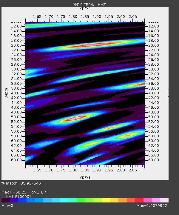
TR04 TR04 - Earthquake Result Viewer

Earthquake location: North Atlantic Ocean
Earthquake latitude/longitude: 14.7/-58.9
Earthquake time(UTC): 2014/02/18 (049) 09:27:13 GMT
Earthquake Depth: 17 km
Earthquake Magnitude: 6.5 MWW, 6.3 MWB, 6.5 MWC, 6.6 MWC, 6.7 MI
Earthquake Catalog/Contributor: NEIC PDE/NEIC COMCAT
Network: YN San Jacinto Fault Zone
Station: TR04 TR04
Lat/Lon: 33.40 N/116.43 W
Elevation: 774 m
Distance: 55.1 deg
Az: 300.605 deg
Baz: 95.229 deg
Ray Param: 0.06503116
Estimated Moho Depth: 50.25 km
Estimated Crust Vp/Vs: 1.81
Assumed Crust Vp: 6.264 km/s
Estimated Crust Vs: 3.461 km/s
Estimated Crust Poisson's Ratio: 0.28
Radial Match: 85.937546 %
Radial Bump: 400
Transverse Match: 71.52854 %
Transverse Bump: 400
SOD ConfigId: 626651
Insert Time: 2014-04-20 19:30:29.998 +0000
GWidth: 2.5
Max Bumps: 400
Tol: 0.001

Signal To Noise

ChannelStoNSTALTA
YN:TR04: :HHZ:20140218T09:36:13.079004Z2.38721638.458952E-73.5434377E-7
YN:TR04: :HHN:20140218T09:36:13.079004Z0.953978844.927651E-75.1653666E-7
YN:TR04: :HHE:20140218T09:36:13.079004Z2.14209587.080009E-73.3051788E-7
Arrivals
Ps6.8 SECOND
PpPs21 SECOND
PsPs/PpSs28 SECOND