You are here: Home > Network List > CI - Caltech Regional Seismic Network Stations List
> Station CIA Catalina Island Airport, California, USA > Earthquake Result Viewer
CIA Catalina Island Airport, California, USA - Earthquake Result Viewer
| Earthquake location: |
Near S. Coast Of Western Honshu |
| Earthquake latitude/longitude: |
33.1/136.6 |
| Earthquake time(UTC): |
2004/09/05 (249) 10:07:07 GMT |
| Earthquake Depth: |
14 km |
| Earthquake Magnitude: |
6.7 MB, 7.0 MS, 7.2 MW, 7.0 MW |
| Earthquake Catalog/Contributor: |
WHDF/NEIC |
|
| Network: |
CI Caltech Regional Seismic Network |
| Station: |
CIA Catalina Island Airport, California, USA |
| Lat/Lon: |
33.40 N/118.42 W |
| Elevation: |
428 m |
|
| Distance: |
83.3 deg |
| Az: |
54.454 deg |
| Baz: |
305.242 deg |
| Ray Param: |
0.0462592 |
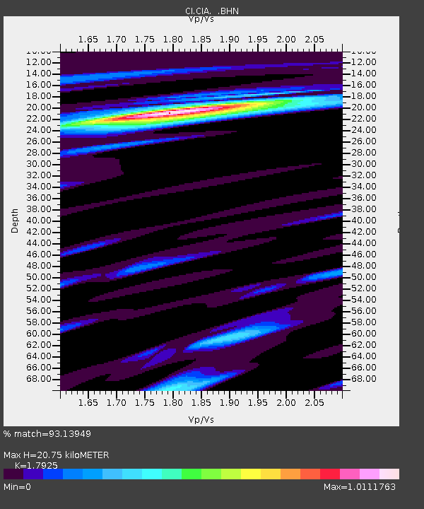
| Estimated Moho Depth: |
20.75 km |
| Estimated Crust Vp/Vs: |
1.79 |
| Assumed Crust Vp: |
6.048 km/s |
| Estimated Crust Vs: |
3.374 km/s |
| Estimated Crust Poisson's Ratio: |
0.27 |
|
| Radial Match: |
93.13949 % |
| Radial Bump: |
388 |
| Transverse Match: |
85.19414 % |
| Transverse Bump: |
400 |
| SOD ConfigId: |
2459 |
| Insert Time: |
2010-02-25 20:56:28.927 +0000 |
| GWidth: |
2.5 |
| Max Bumps: |
400 |
| Tol: |
0.001 |
|
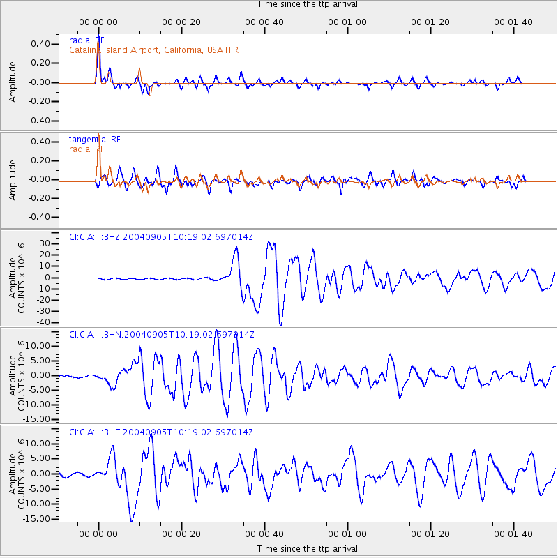
Signal To Noise
| Channel | StoN | STA | LTA |
| CI:CIA: :BHN:20040905T10:19:02.697014Z | 3.5492747 | 2.3102405E-6 | 6.5090495E-7 |
| CI:CIA: :BHE:20040905T10:19:02.697014Z | 7.368431 | 4.26207E-6 | 5.78423E-7 |
| CI:CIA: :BHZ:20040905T10:19:02.697014Z | 29.491213 | 1.3241181E-5 | 4.4898732E-7 |
| Arrivals |
| Ps | 2.8 SECOND |
| PpPs | 9.4 SECOND |
| PsPs/PpSs | 12 SECOND |


