You are here: Home > Network List > AV - Alaska Volcano Observatory Stations List
> Station SPCR Ckakachatna River, Mount Spurr, Alaska > Earthquake Result Viewer
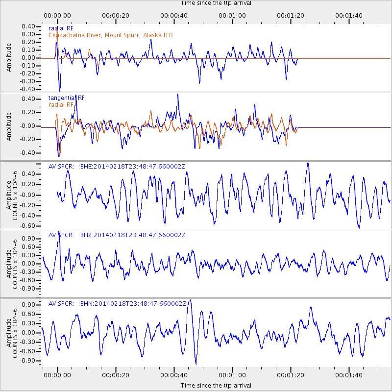
SPCR Ckakachatna River, Mount Spurr, Alaska - Earthquake Result Viewer
*The percent match for this event was below the threshold and hence no stack was calculated.
| Earthquake location: |
Near Coast Of Peru |
| Earthquake latitude/longitude: |
-14.2/-75.6 |
| Earthquake time(UTC): |
2014/02/18 (049) 23:35:58 GMT |
| Earthquake Depth: |
57 km |
| Earthquake Magnitude: |
6.0 MWB, 5.9 MWW, 5.9 MWC, 6.0 MWC |
| Earthquake Catalog/Contributor: |
NEIC PDE/NEIC COMCAT |
|
| Network: |
AV Alaska Volcano Observatory |
| Station: |
SPCR Ckakachatna River, Mount Spurr, Alaska |
| Lat/Lon: |
61.20 N/152.21 W |
| Elevation: |
984 m |
|
| Distance: |
96.0 deg |
| Az: |
331.73 deg |
| Baz: |
108.422 deg |
| Ray Param: |
$rayparam |
*The percent match for this event was below the threshold and hence was not used in the summary stack. |
|
| Radial Match: |
56.244587 % |
| Radial Bump: |
400 |
| Transverse Match: |
63.67657 % |
| Transverse Bump: |
311 |
| SOD ConfigId: |
626651 |
| Insert Time: |
2014-04-20 19:48:44.591 +0000 |
| GWidth: |
2.5 |
| Max Bumps: |
400 |
| Tol: |
0.001 |
|
Signal To Noise
| Channel | StoN | STA | LTA |
| AV:SPCR: :BHZ:20140218T23:48:47.660002Z | 1.8057486 | 5.128132E-7 | 2.8398927E-7 |
| AV:SPCR: :BHN:20140218T23:48:47.660002Z | 1.2283176 | 3.2652235E-7 | 2.658289E-7 |
| AV:SPCR: :BHE:20140218T23:48:47.660002Z | 1.1359688 | 2.1983396E-7 | 1.9352113E-7 |
| Arrivals |
| Ps | |
| PpPs | |
| PsPs/PpSs | |


